Austad (municipality)
| Austad herred | |
|---|---|
| Former Municipality | |

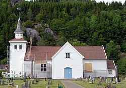
View of the local church
|
|
| Location of the municipality | |
| Coordinates: 58°05′30″N 07°02′45″E / 58.09167°N 7.04583°ECoordinates: 58°05′30″N 07°02′45″E / 58.09167°N 7.04583°E | |
| Country | Norway |
| Region | Southern Norway |
| County | Vest-Agder |
| District | Lister |
| Municipality ID | NO-1031 |
| Adm. Center | Austad |
| Area | |
| • Total | 44 km2 (17 sq mi) |
| Time zone | CET (UTC+01:00) |
| • Summer (DST) | CEST (UTC+02:00) |
| Created from | Lyngdal in 1909 |
| Merged into | Lyngdal in 1963 |
Austad is a former municipality in Vest-Agder county, Norway. The 44-square-kilometre (17 sq mi) municipality existed from 1909 until its dissolution in 1963. The municipality encompassed the area surrounding the Rosfjorden in the southern, coastal part of the present-day municipality of Lyngdal. The administrative centre of the municipality was the village of Austad where Austad Church is located.
The municipality (originally the parish) is named after the old Austad farm (Old Norse: Alvisstaðir). The first element of the name is derived from the male name "Ålvir" and the last element is "stad" (Old Norse: staðir) which means "homestead" or "farm".
Austad municipality was created on 1 January 1909 when the old municipality of Lyngdal was divided into three separate municipalities: Lyngdal, Austad, and Kvås. Upon its creation, Austad had a population of 1,263. On 7 January 1916, there was a small border adjustment which transferred a small area (population: 4) from Austad to the neighboring municipality of Spind. On 1 January 1963, Austad and Kvås were re-incorporated into Lyngdal along with the Gitlevågområdet area of Spangereid. Prior to the merger, Austad had a population of 608.
...
Wikipedia


