Aurora, Zamboanga del Sur
| Aurora | ||
|---|---|---|
| Municipality | ||
|
||
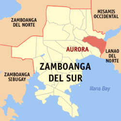
 Map of Zamboanga del Sur with Aurora highlighted |
||
| Location within the Philippines | ||
| Coordinates: 07°57′N 123°35′E / 7.950°N 123.583°ECoordinates: 07°57′N 123°35′E / 7.950°N 123.583°E | ||
| Country | Philippines | |
| Region | Zamboanga Peninsula (Region IX) | |
| Province | Zamboanga del Sur | |
| District | 1st district of Zamboanga del Sur | |
| Founded | August 22, 1942 | |
| Barangays | 44 | |
| Government | ||
| • Mayor | Enrique J. Cabahug (Liberal Party) | |
| Area | ||
| • Total | 180.95 km2 (69.87 sq mi) | |
| Population (2015 census) | ||
| • Total | 50,755 | |
| • Density | 280/km2 (730/sq mi) | |
| Time zone | PST (UTC+8) | |
| ZIP code | 7020 | |
| Dialing code | +63 (0)62 | |
| Income class | 2nd municipal income class | |
| 097302000 | ||
| Electorate | 29,951 voters as of 2016 | |
| Website | www |
|
Aurora is a second class municipality in the province of Zamboanga del Sur, Philippines. According to the 2015 census, it has a population of 50,755 people.
It is the easternmost municipality in Zamboanga del Sur, bounded by the Province of Lanao del Norte on its eastern side. The town was named after President Manuel Quezon's wife, Aurora Quezon.
In 1948, a portion of Aurora was separated to form the town of Molave.
Aurora is politically subdivided into 44 barangays.
...
Wikipedia


