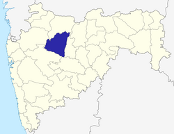
Aurangabad District, Maharashtra
|
Aurangabad district औरंगाबाद जिल्हा |
|
|---|---|
| District of Maharashtra | |
 Location of Aurangabad district in Maharashtra |
|
| Country | India |
| State | Maharashtra |
| Administrative division | Aurangabad Division |
| Headquarters | Aurangabad, Maharashtra |
| Tehsils | 1. Aurangabad, 2. Paithan, 3. Vaijapur, 4. Gangapur, 5. Khuldabad, 6. Phulambri, 7. Kannad, 8. Sillod, 9. Soegaon |
| Government | |
| • Lok Sabha constituencies | 1. Aurangabad, 2. Jalna (shared with Jalna district) (based on Election Commission website) |
| Area | |
| • Total | 10,100 km2 (3,900 sq mi) |
| Population (2011) | |
| • Total | 3,695,928 |
| • Density | 370/km2 (950/sq mi) |
| • Urban | 37.53% |
| Demographics | |
| • Literacy | 61.15% |
| • Sex ratio | 924 |
| Major highways | NH-211 |
| Average annual precipitation | 734 mm |
| Website | Official website |
| Aurangabad | ||||||||||||||||||||||||||||||||||||||||||||||||||||||||||||
|---|---|---|---|---|---|---|---|---|---|---|---|---|---|---|---|---|---|---|---|---|---|---|---|---|---|---|---|---|---|---|---|---|---|---|---|---|---|---|---|---|---|---|---|---|---|---|---|---|---|---|---|---|---|---|---|---|---|---|---|---|
| Climate chart () | ||||||||||||||||||||||||||||||||||||||||||||||||||||||||||||
|
||||||||||||||||||||||||||||||||||||||||||||||||||||||||||||
|
||||||||||||||||||||||||||||||||||||||||||||||||||||||||||||
| J | F | M | A | M | J | J | A | S | O | N | D |
|
2.8
29
12
|
2.1
32
14
|
3.3
36
19
|
3.5
38
22
|
24
38
25
|
114
34
24
|
116
30
22
|
120
29
21
|
122
30
21
|
61
32
19
|
11
30
15
|
6.5
28
12
|
| Average max. and min. temperatures in °C | |||||||||||
| Precipitation totals in mm | |||||||||||
| Source: MSN Weather | |||||||||||
| Imperial conversion | |||||||||||
|---|---|---|---|---|---|---|---|---|---|---|---|
| J | F | M | A | M | J | J | A | S | O | N | D |
|
0.1
84
54
|
0.1
90
57
|
0.1
97
66
|
0.1
100
72
|
1
100
77
|
4.5
93
75
|
4.6
86
72
|
4.7
84
70
|
4.8
86
70
|
2.4
90
66
|
0.4
86
59
|
0.3
82
54
|
| Average max. and min. temperatures in °F | |||||||||||
| Precipitation totals in inches | |||||||||||
...
Wikipedia
