Aughton, Lancashire
| Aughton | |
|---|---|
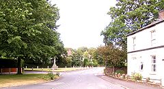
 Holt Green, Aughton |
|
| Aughton shown within Lancashire | |
| Population | 8,342 (2001 Census) |
| OS grid reference | SD395055 |
| Civil parish |
|
| District | |
| Shire county | |
| Region | |
| Country | England |
| Sovereign state | United Kingdom |
| Post town | ORMSKIRK |
| Postcode district | L39 |
| Dialling code | 01695 |
| Police | Lancashire |
| Fire | Lancashire |
| Ambulance | North West |
| EU Parliament | North West England |
| UK Parliament | |
Aughton is a village and civil parish in the West Lancashire district of Lancashire, England, between Ormskirk and Maghull. It is a residential area with tree lined roads being found in all parts of the parish and an area of 1,658 hectares. The northern part is known as Aughton village, the south-west as Holt Green and the south-east as Town Green.
At the 2001 Census, Aughton had a population of 8,342, reducing to 8,068 at the 2011 Census. The parish includes Aughton village itself, and part of the Aughton Park estate, which is a southern suburb of Ormskirk, along with Town Green in the south-east and Holt Green in the south-west.
Aughton has its own parish council, is part of the Aughton and Downholland electoral ward for West Lancashire District Council elections and the West Lancashire constituency for the House of Commons elections.
Aughton is bounded on the west by the A59 Liverpool to Preston road and bisected to the east by the B5197 Ormskirk to Kirkby road that runs north-south through the village.
The parish has two railway stations, Town Green and Aughton Park, both on the Northern Line of the Merseyrail network, and part of the former Liverpool, Ormskirk and Preston Railway.
...
Wikipedia

