Auchterhouse
| Auchterhouse | |
|---|---|
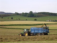
 Silage making near Kirkton, in Auchterhouse |
|
| Auchterhouse shown within Scotland | |
| Population | 520 (2001) |
| OS grid reference | NO3337 |
| Civil parish |
|
| Council area | |
| Lieutenancy area | |
| Country | Scotland |
| Sovereign state | United Kingdom |
| Post town | DUNDEE |
| Postcode district | DD3 |
| Dialling code | 01382 |
| Police | Scottish |
| Fire | Scottish |
| Ambulance | Scottish |
| EU Parliament | Scotland |
| UK Parliament | |
| Scottish Parliament | |
Auchterhouse is a village, community, and civil parish in the Scottish council area of Angus, located 7.3 miles (11.7 km) north west of Dundee, 9.5 miles (15.3 km) south east of Alyth and 14.9 miles (24.0 km) south west of Forfar. It lies on the southern edge of the Sidlaw Hills, below Auchterhouse Hill, 1,398 feet (426 m) high. The parish, which is coterminous with the community, had a population of 520 in 2001. The village, formerly known as Milltown of Auchterhouse, straddles the B954 Muirhead to Newtyle road. About 1.0 mile (1.6 km) east lies the larger village of Kirkton of Auchterhouse, where the church and school are located.
Singer Billy MacKenzie lived in the village from 1991 until his death in 1997. Kirkton, in Auchterhouse, was the subject of the painting 'Sidlaw Village, Winter' by James MacIntosh Patrick.
The earliest human settlement discovered around Auchterhouse dates from 3500 to 1000 BC, in the form of stone and bronze tools used by the first farmers to clear woodland. Wheat and barley were grown, and cattle and sheep kept, while a decorated sandstone spindle whorl found at Bonnyton, north of the village, and now kept at the McManus Galleries in Dundee, indicates that wool was spun into thread. A possible henge in Dronley Wood has been revealed by aerial photography, and a stone circle at Templelands was destroyed during railway construction in the 19th century.
A stone cairn on West Mains Hill, excavated in 1897, was found to conceal a double burial cist, typical of the period around 2000 BC. The cist contained burnt bones and a bronze dagger blade with ox-horn hilt, which are now in the National Museum of Scotland in Edinburgh. Other cists were reportedly discovered in the 19th century, and a circular burial mound survives south of Dronley House. Cup marks on stones were found around Auchterhouse Park.
...
Wikipedia

