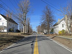
Atkinson, New Hampshire
| Atkinson, New Hampshire | |
|---|---|

Main Street
|
|
 Location in Rockingham County and the state of New Hampshire. |
|
| Coordinates: 42°50′18″N 71°08′49″W / 42.83833°N 71.14694°WCoordinates: 42°50′18″N 71°08′49″W / 42.83833°N 71.14694°W | |
| Country | United States |
| State | New Hampshire |
| County | Rockingham |
| Incorporated | 1767 |
| Government | |
| • Board of Selectmen | Harold J. Morse, Chair Philip V. Consentino William M. Baldwin William G. Friel Jason B. Grosky |
| • Town Administrator | Alan J. Phair |
| Area | |
| • Total | 11.3 sq mi (29.2 km2) |
| • Land | 11.1 sq mi (28.8 km2) |
| • Water | 0.2 sq mi (0.4 km2) 1.42% |
| Elevation | 302 ft (92 m) |
| Population (2010) | |
| • Total | 6,751 |
| • Density | 600/sq mi (230/km2) |
| Time zone | Eastern (UTC-5) |
| • Summer (DST) | Eastern (UTC-4) |
| ZIP code | 03811 |
| Area code(s) | 603 |
| FIPS code | 33-02340 |
| GNIS feature ID | 0873535 |
| Website | www.town-atkinsonnh.com |
Atkinson is a town in Rockingham County, New Hampshire, United States. The population was 6,751 at the 2010 census.
Atkinson has a rich history, dating back to the American Revolution. The community was incorporated 3 September 1767, and was named after Colonel Theodore Atkinson, a local landowner.
Atkinson Academy, the second-oldest co-educational school in the country, was founded as a boys' school in 1787 by Reverend Stephen Peabody, General Nathaniel Peabody and Doctor William Cogswell; it began admitting girls in 1791. The school building burnt to the ground in 1802, and was rebuilt in 1803 at a cost of $2,500. That building remains a part of the Academy, with only four classrooms. Other historic buildings, such the Atkinson Historical Society and Library, Rockwell School (current police station), and many more, grace this southern New Hampshire town with their rich historical value and education of the history of the area.
Relatives of former President John Quincy Adams live in Atkinson, along with famous politicians and businessmen. Atkinson’s history can be read about in depth in the book Atkinson Then and Now, which can be purchased at the Atkinson Public Library on Academy Avenue.
According to the United States Census Bureau, the town has a total area of 11.3 square miles (29 km2), of which 11.1 sq mi (29 km2) is land and 0.2 sq mi (0.52 km2) is water, comprising 1.42% of the town. The highest point in Atkinson is Hog Hill, at 430 feet (130 m) above sea level. Atkinson lies fully within the Merrimack River watershed.
In 2011 the New Hampshire Scenic and Cultural Byways program named 3.74 miles of Main Street the "Stage Coach Byway".
As of the census of 2000, there were 6,178 people, 2,317 households, and 1,777 families residing in the town. The population density was 555.2 people per square mile (214.3/km²). There were 2,431 housing units at an average density of 218.5 per square mile (84.3/km²). The racial makeup of the town was 97.62% White, 0.26% African American, 0.06% Native American, 1.18% Asian, 0.21% from other races, and 0.66% from two or more races. Hispanic or Latino of any race were 0.70% of the population.
...
Wikipedia
