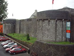
Athlone Castle
| Athlone Castle | |
|---|---|
| Part of the City of Athlone | |
| Athlone, Westmeath in Ireland | |
 |
|
|
Location in Ireland
|
|
| Coordinates | 53°25′24″N 7°56′33″W / 53.42333°N 7.94250°WCoordinates: 53°25′24″N 7°56′33″W / 53.42333°N 7.94250°W |
| Type | Castle |
| Site information | |
| Owner | City of Athlone, Ireland |
| Operator | Old Athlone Society |
| Open to the public |
Yes |
| Condition | Restored |
| Website | athlonehistory |
| Site history | |
| Built | 1129 (Wooden fort), 1210 (Motte-and-Bailey) |
| Built by | Tairrdelbach Ua Conchobair |
| In use | 1129-1800s |
| Battles/wars | Siege of Athlone |
Athlone Castle is a castle located in Athlone, Westmeath, Ireland dating from the 12th century and is a popular tourist destination.
The earliest recorded “castle” of Athlone was a wooden structure built in 1129, by King Tairrdelbach Ua Conchobair of Connacht, possibly on the site of the present castle. The stone castle which survives today dates from 1210 and was built for King John by his Irish Justiciar, Bishop John de Gray of Norwich. It was built to defend the crossing point of the river at Athlone and to provide a bridgehead to facilitate the Norman advance into Connaught.
The castle of 1210 was a free standing polygonal tower built on a newly built (or existing) ‘motte’ or man-made hill. This tower, though greatly altered, can still be seen as the central keep or ‘donjon’ of the castle today. At the time the castle was built the Shannon, as it passed through Athlone, was very different from today. It is likely that in the early days of its existence the castle enjoyed the protection of a fosse or moat.
The castle was greatly fortified in the late 13th century (c1276) when the original ‘motte’ was surrounded with a curtain wall with three-quarter round towers (or drum towers) at the corner. These features, again greatly rebuilt, still survive today. The castle was reconstructed by Sir William Brabazon (Lord Justice of Ireland) in 1547. The external walls and towers came under heavy fire during the Sieges of Athlone in 1690-91 and were later destroyed when lightning struck the castle in 1697. The castle as we view it today shows signs of extensive remodelling during the Napoleonic era when it was modernised and adapted for artillery. Today the squat drum towers are somewhat reminiscent of the Martello towers (again of the Napoleonic era) which are found around Dublin.
The large scale Ordnance Survey map of 1874 names some of the features which were then extant on the castle. These include: Officers’ quarters & soldiers’ quarters; master gunners’ quarters; guard house; ablutions room; cook house; kitchen; guard house and draw bridge. The officers’ quarters and soldiers’ quarters were located in the five-bay, two-storey barrack building which overlooks Main Street. This late Georgian building dates to c1810.
...
Wikipedia


