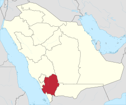
Asir Region
|
'Asir عسير |
|
|---|---|
| Region | |
 Map of Saudi Arabia with 'Asir highlighted |
|
| Capital | Abha |
| Boroughs | 12 |
| Government | |
| • Governor | Faisal bin Khalid |
| • Vice Governor | Mansour bin Muqrin |
| Area | |
| • Total | 81,000 km2 (31,000 sq mi) |
| Population (2010) | |
| • Total | 3,881,461 |
| ISO 3166-2 | 14 |
Coordinates: 19°0′N 43°0′E / 19.000°N 43.000°E
The 'Asir Region (or 'Aseer, Arabic: عسير ʿAsīr) is a region of Saudi Arabia located in the southwest of the country that is named after the ʿAsīr tribe. It has an area of 81,000 square kilometres (31,000 sq mi) and an estimated population of 2,190,000. It shares a short border with Yemen.
The capital of the Asir Region is Abha. Other towns include Khamis Mushait, Bisha and Bareq. The regional governor is Faisal bin Khalid bin Abdulaziz Al Saud (appointed 16 May 2007), a son of King Khalid of Saudi Arabia. He replaced his cousin, Khalid bin Faisal Al Saud, who was made governor of Makkah Region the same day.
Geographically, the 'Asir Region is situated on a high plateau that receives more rainfall than the rest of the country and contains the country's highest peaks, which rise to almost 3,000 metres (9,800 ft) at Jabal Sawda near Abha. Though data is exceedingly sparse and unreliable, the average annual rainfall in the highlands probably ranges from 300 to 500 millimetres (12 to 20 in) falling in two rainy seasons, the chief one being in March and April, with some rain in the summer. Temperatures are very extreme, with diurnal temperature ranges in the highlands the greatest in the world. It is common for afternoon temperatures to be over 30 °C (86 °F), yet mornings can be extremely frosty and fog can cut visibility to near zero percent. As a result, there is much more natural vegetation in 'Asir than in any other part of Saudi Arabia, with sheltered areas even containing areas of dense coniferous forests, though more exposed ridges still are very dry.
...
Wikipedia
