Ashmore
| Ashmore | |
|---|---|
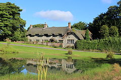
 Ashmore pond |
|
| Ashmore shown within Dorset | |
| Population | 188 |
| OS grid reference | ST912178 |
| • London | 116 miles (187 km) |
| Civil parish |
|
| District | |
| Shire county | |
| Region | |
| Country | England |
| Sovereign state | United Kingdom |
| Post town | Salisbury |
| Postcode district | SP5 |
| Dialling code | 01722 |
| Police | Dorset |
| Fire | Dorset and Wiltshire |
| Ambulance | South Western |
| EU Parliament | South West England |
| UK Parliament | |
Ashmore is a village and civil parish in the North Dorset district of Dorset, England, situated 20 miles (32 km) south-west of Salisbury. The village is centred on a circular pond and consists of a church and several stone cottages and farms, many with thatched roofs. It is the highest village in the county. The pond or "mere" is what gave the village its original name of "Ashmere". In the 2011 census the parish had a population of 188.
Three round barrows have been found in the parish: two in the south near Well Bottom and one in the west near the boundary with Fontmell Magna; this latter barrow was removed in the 19th century and bones were recovered. Ashmore may have been the site of a Neolithic market place or settlement.
The Roman road from Bath to Badbury Rings passes through the east of the parish. The situation of the village is similar to Romano-British sites in the area, and there may have been a Roman military camp and trading post here. It is possible that Ashmore may have been a Romano-British village that has been occupied without a break up to the present day; the parish church is sited away from the pond at the edge of the village, which could indicate that the village pre-dated the church and Christianity.
In 1086 Ashmore was recorded in the Domesday Book as "Aisemare"; it had 24 households, 7 ploughlands and 10 acres (4.0 ha) of meadow. It was in Cranborne Hundred and had a value of £15 to the lord of the manor, who was King William.
Until 1859 Ashmore had an open field system; the three fields—North Field to the north, and Sandpit Fields and Broadridge to the south—were roughly equal in size and covered an area of 380 acres (150 ha). At the same time there was also a considerable area of enclosed fields, covering 240 acres (97 ha) in 1590.
...
Wikipedia

