Ashford, Middlesex
| Ashford | |
|---|---|
 St Matthew's C of E Church |
|
 Church Road |
|
| Ashford shown within Surrey | |
| Area | 6.71 km2 (2.59 sq mi) |
| Population | 27,382 (2011 census) |
| • Density | 4,081/km2 (10,570/sq mi) |
| OS grid reference | TQ065715 |
| Civil parish |
|
| District | |
| Shire county | |
| Region | |
| Country | England |
| Sovereign state | United Kingdom |
| Post town | ASHFORD |
| Postcode district | TW15 |
| Dialling code | 01784 |
| Police | Surrey |
| Fire | Surrey |
| Ambulance | South East Coast |
| EU Parliament | South East England |
| UK Parliament | |
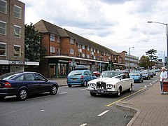
Ashford is a town and suburb of London located almost entirely in the Surrey borough of Spelthorne, but with a small section lying within the London Borough of Hounslow, England. Mostly residential, Ashford is 13.5 miles (21.7 km) WSW of Charing Cross, London, forms part of the London commuter belt, with a minor stop on the Waterloo to Reading Line (which has two branch lines) and has a long commercial high street. It is centred 2.5 miles (4.0 km) south of London Heathrow Airport, to which a portion of its economy relates, including business premises relating to aviation and the distribution of air freight – the main cargo depot being next to an adjoining village, Stanwell.
More usually referred to as Ashford, Middlesex to distinguish it from the larger town of Ashford, Kent, since 1965 when Middlesex County Council was dissolved the town's wards are officially in Ashford, Surrey and for example the current railway services provider uses the present or past county variously throughout its stations and trains. A leading gymnastics club, HMP Bronzefield and one of the sites of Brooklands College are in the town. Ashford Hospital is narrowly within Stanwell and began as Ashford's workhouse. Ashford Common has a parade of shops and is a more residential ward that includes part of the Queen Mary Reservoir and all of its related water treatment works, which is contiguous with and subsidiary to the town itself.
...
Wikipedia

