Asahi-ku, Yokohama
|
Asahi 旭区 |
||
|---|---|---|
| Ward | ||
| Asahi Ward | ||
|
||
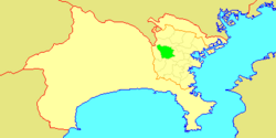
 Location of Asahi in Kanagawa |
||
| Coordinates: 35°28′29″N 139°32′41″E / 35.47472°N 139.54472°ECoordinates: 35°28′29″N 139°32′41″E / 35.47472°N 139.54472°E | ||
| Country | Japan | |
| Region | Kantō | |
| Prefecture | Kanagawa | |
| City | Yokohama | |
| Area | ||
| • Total | 32.77 km2 (12.65 sq mi) | |
| Population (February 2010) | ||
| • Total | 249,045 | |
| • Density | 7,600/km2 (20,000/sq mi) | |
| Time zone | Japan Standard Time (UTC+9) | |
| - Tree | Enkianthus | |
| - Flower | Japanese Morning Glory | |
| Phone number | 045-954-6161 | |
| Address | 1-4-12 Tsurugamine , Asahi-ku Yokohama-shi, Kanagawa-ken 241-0022 | |
| Website | web |
|
Asahi-ku (旭?) is one of the 18 wards of the city of Yokohama in Kanagawa Prefecture, Japan. As of 2010, the ward has an estimated population of 249,045 and a population density of 7,600 persons per km². The total area is 32.77 km².
Asahi is located in eastern Kanagawa Prefecture, and on the northwest borders of the city of Yokohama.
The area around present-day Asahi Ward was formerly part of Tsuzuki District in Musashi Province. By the Heian period it was part of a huge shōen administered by the Hangaya clan, a subsidiary of the Hatakeyama clan. During the Edo period, it was a rural region classified as tenryō territory controlled directly by the Tokugawa shogunate, but administered through various hatamoto. After the Meiji Restoration, the area became part of the new Kanagawa Prefecture in 1868. In the cadastral reform of April 1, 1889, the area was divided into numerous villages. During the Meiji period, the area was a center for sericulture. The area began to urbanize only during the 1920s and 1930s with the building of the Sagami Railway Main Line. On October 1, 1927 it was annexed by the neighboring city of Yokohama, becoming part of Hodogaya Ward. In a major administrative reorganization of October 1, 1969, Asahi Ward was separated from Hodogaya Ward, becoming an independent ward within the city of Yokohama.
...
Wikipedia


