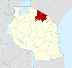
Arusha Region
|
Arusha Region Mkoa wa Arusha (Swahili) |
|
|---|---|
| Region | |

|
|
 |
|
| Country | Tanzania |
| Zone | Northern |
| Capital | Arusha |
| Government | |
| • Regional Commissioner | Magesa Stanslaus Mulongo |
| Area | |
| • Total | 37,576 km2 (14,508 sq mi) |
| • Land | 33,809 km2 (13,054 sq mi) |
| • Water | 707 km2 (273 sq mi) |
| Population (2012) | |
| • Total | 1,694,310 |
| • Density | 45/km2 (120/sq mi) |
| Time zone | EAT (UTC+3) |
| Postcode | 23xxx |
| Area code(s) | 027 |
| Website | arusha |
Arusha Region is one of Tanzania's 30 administrative regions. Its capital and largest city is the city of Arusha. The region is bordered by Kajiado County and Narok County in Kenya to the north, the Kilimanjaro Region to the east, the Manyara and Singida regions to the south, and the Mara and Simiyu regions to the west. Major towns include Monduli, Namanga, Longido, and Loliondo to the north, Mto wa Mbu and Karatu to the west, and Usa River to the east. The region is comparable in size to the combined land and water areas of the United States state of Maryland.
Arusha Region is a global tourist destination and is the center of the northern Tanzania safari circuit. The national parks and reserves in this region include Ngorongoro Conservation Area, Arusha National Park, the Loliondo Game Controlled Area, and part of Lake Manyara National Park. Remains of 600-year-old stone structures are found at Engaruka, just off the dirt road between Mto wa Mbu and Lake Natron. With a HDI of 0.721, Arusha is one among the most developed regions of Tanzania.
Much of the present area of Arusha Region used to be Maasai land. The Maasai are still the dominant community in the region. Their influence is reflected in the present names of towns, regional culture, cuisine, and geographical features.
...
Wikipedia
