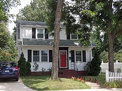
Arlington Heights, Virginia
|
Arlington Heights Historic District
|
|
 |
|
| Location | Bounded by Arlington Blvd., S. Fillmore St., S. Walter Reed Dr., Columbia Pk., & S. Glebe Rd., Arlington, Virginia |
|---|---|
| Coordinates | 38°52′2″N 77°5′27″W / 38.86722°N 77.09083°WCoordinates: 38°52′2″N 77°5′27″W / 38.86722°N 77.09083°W |
| Area | 177.1 acres (71.7 ha) |
| Built | 1909 |
| Architect | Beger, Charles; Behm, Fred et al. |
| Architectural style | Colonial Revival, Tudor Revival, et al. |
| MPS | Garden Apartments, Apartment Houses and Apartment Complexes in Arlington County, Virginia MPS |
| NRHP Reference # | 08000063 |
| VLR # | 000-3383 |
| Significant dates | |
| Added to NRHP | February 21, 2008 |
| Designated VLR | December 5, 2007 |
The Arlington Heights Historic District is a national historic district located at Arlington County, Virginia. It contains 737 contributing buildings and 1 contributing site in a residential neighborhood in central Arlington. The area was formed from the integration of twenty-five subdivisions platted between 1909 and 1978. Single-family dwellings include representative examples of the Tudor Revival and Colonial Revival styles. The district is primarily a single-family residential neighborhood with a number of twin dwellings, is also home to garden apartments, one high-rise apartment building, a commercial building, a synagogue, a parsonage, a middle school with community center, and two landscaped parks.
It was listed on the National Register of Historic Places in 2008.
...
Wikipedia


