Arizona State Route 264
| State Route 264 | ||||
|---|---|---|---|---|
 |
||||
| Route information | ||||
| Maintained by ADOT | ||||
| Length: | 154.35 mi (248.40 km) | |||
| Existed: | 1961 – present | |||
| Major junctions | ||||
| West end: |
|
|||
|
|
||||
| East end: |
|
|||
| Highway system | ||||
|
||||
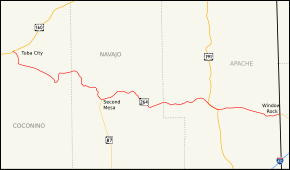
State Route 264 (SR 264) is a highway in northeastern Arizona that runs from its junction with US 160 in Tuba City to the border with New Mexico. The roadway is still numbered 264 into New Mexico to its junction with US 491.
The western terminus of SR 264 is located at a junction with US 160 in Tuba City. The highway heads towards the southeast and then south from this junction until it reaches BIA Route 6710. At this junction, SR 264 begins to heads towards the southeast. It continues on this heading until it curves towards the south southeast of Coal Mine Mesa. The highway curves back towards the east and then north as it follows the terrain of the area. The highway curves back towards the east just prior to an intersection with BIA Route 6660. It continues towards the east to a junction with BIA Route 62 where SR 264 curves towards the southeast. The highway curves towards the south just prior to passing through Hotevilla. It curves back towards the east when it reaches Old Oraibi. The highway curves back towards the south until it reaches the northern terminus of SR 87 in Second Mesa. From here, it heads east, passing through Polacca and Keams Canyon. SR 264 continues to the southeast until it curves back toward the east at an intersection with BIA Route 6. SR 264 continues east to a junction with US 191 in Burnside and the two run concurrently until they reach Ganado. US 191 heads south from this junction as SR 264 heads east. SR 264 continues east to Window Rock just prior to crossing the New Mexico border and continuing as New Mexico State Road 264.
...
Wikipedia

