Apače
| Apače | |
|---|---|

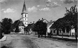
Postcard of Apače before WW2
|
|
| Location in Slovenia | |
| Coordinates: 46°41′48.1″N 15°54′40.12″E / 46.696694°N 15.9111444°ECoordinates: 46°41′48.1″N 15°54′40.12″E / 46.696694°N 15.9111444°E | |
| Country |
|
| Traditional region | Styria |
| Statistical region | Mura |
| Municipality | Apače |
| Area | |
| • Total | 4.4 km2 (1.7 sq mi) |
| Elevation | 218 m (715 ft) |
| Population (2002) | |
| • Total | 636 |
Apače (pronounced [ˈaːpatʃɛ]; German: Abstall) is a town in Slovenia and it is located on the border between Slovenia and Austria. It is the seat of the Municipality of Apače, which is the northernmost municipality in the traditional region of Styria. It now belongs to the Mura Statistical Region. It is located 25 kilometers northeast of Maribor and 20 kilometers west of Murska Sobota.
The parish church in the settlement is dedicated to the Assumption of Mary and belongs to the Roman Catholic Archdiocese of Maribor. It dates to the 15th and 16th centuries. The Freudenau Mansion is located near the town. It is an originally 17th-century Baroque mansion and it was renovated in a Neoclassical style in the 19th century.
...
Wikipedia

