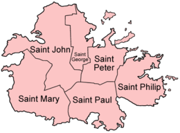
Antigua Island
| Native name: Waladli or Wadadli | |
|---|---|

Map of Antigua showing the parishes
|
|
 |
|
| Geography | |
| Location | Caribbean Sea |
| Coordinates | 17°5′N 61°48′W / 17.083°N 61.800°WCoordinates: 17°5′N 61°48′W / 17.083°N 61.800°W |
| Archipelago | Leeward Islands |
| Total islands | 2 |
| Area | 281 km2 (108 sq mi) |
| Coastline | 87 km (54.1 mi) |
| Highest elevation | 402 m (1,319 ft) |
| Highest point | Mount Obama / Boggy Peak |
| Administration | |
|
Antigua and Barbuda
|
|
| Largest settlement | St. John's (pop. 32,000) |
| Demographics | |
| Population | 80,161 (2011 Census) |
| Pop. density | 285.2 /km2 (738.7 /sq mi) |
| Ethnic groups | 91% Black or Mulatto, 4.4% Other Mixed Race, 1.7% White, 2.9% Other |
Antigua (/ænˈtiːɡə/ an-TEE-ga), also known as Waladli or Wadadli by the native population, is an island in the West Indies. It is one of the Leeward Islands in the Caribbean region and the main island of the country of Antigua and Barbuda. Antigua and Barbuda became an independent state within the Commonwealth of Nations on 1 November 1981.
Antigua means "ancient" in Spanish after an icon in Seville Cathedral, —St. Mary of the Old Cathedral. The name Waladli comes from the indigenous inhabitants and means approximately "our own". The island's circumference is roughly 87 km (54 mi) and its area 281 km2 (108 sq mi). Its population was 80,161 (at the 2011 Census). The economy is mainly reliant on tourism, with the agricultural sector serving the domestic market.
Over 32,000 people live in the capital city, St. John's, at 17°6′N 61°45′W / 17.100°N 61.750°W. The capital is situated in the north-west and has a deep harbour which is able to accommodate large cruise ships. Other leading population settlements are All Saints (3,412) and Liberta (2,239), according to the 2001 census.
...
Wikipedia
