Anstey Hill Recreation Park
|
Anstey Hill Recreation Park South Australia |
|
|---|---|
|
IUCN category III (natural monument or feature)
|
|

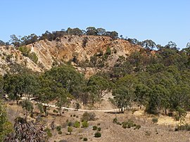
Quarry in the northwest of Anstey Hill Recreation Park
|
|
| Nearest town or city | Adelaide |
| Coordinates | 34°49′50.38″S 138°44′15.45″E / 34.8306611°S 138.7376250°ECoordinates: 34°49′50.38″S 138°44′15.45″E / 34.8306611°S 138.7376250°E |
| Established | 1989 |
| Area | 3.62 km2 (1.4 sq mi) |
| Managing authorities | Department of Environment, Water and Natural Resources |
| Website | Anstey Hill Recreation Park |
| See also | Protected areas of South Australia |
Anstey Hill Recreation Park is a 362-hectare (890-acre) protected area established in 1989 and located approximately 19 kilometres (12 mi) northeast of Adelaide, South Australia. The park is a significant reserve of bushland in the foothills of the Mount Lofty Ranges and is home to rare or vulnerable native plants and animals, and problematic invasive species. It is managed by the City of Tea Tree Gully, the Department of Environment, Water and Natural Resources and a volunteer group—The Friends of Anstey Hill. The park is designed for recreational walking and has no visitor facilities. It is managed in association with the regional planning initiative known as of Yurrebilla, the Greater Mount Lofty Parklands.
The park's land was gradually acquired by the Government of South Australia beginning in 1966, based on recommendations in a 1962 report. From 1981 onwards, plans were published that aimed to develop the area for commercial purposes, but public pressure led to its declaration as a public reserve in 1989. The last land added was a small area in 2003. Anstey Hill is a 371-metre-high (1,217 ft) peak in the park's south. Both hill and park are named after a road built by agricultural pioneer George Alexander Anstey. Fire authorities regard the park as an "arson hotspot", and it is frequently burned by bushfires—mostly deliberately lit. There is no permanent water except for springs in Water Gully, adjacent to ruins of a nursery, although there are many seasonal creeks. Much of the land is steep, rising 200 m (660 ft) across the park's breadth, with gradients often steeper than one in three. Erosion and land movements due to a significant geologic fault zone created this land form. The Gun Emplacement, a listed Geologic Monument and remnant of an ancient land surface, lies in the southwestern corner.
...
Wikipedia

