Angarrack
| Angarrack | |
|---|---|
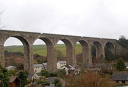
 Angarrack village under the railway viaduct |
|
| Angarrack shown within Cornwall | |
| OS grid reference | SW584382 |
| Unitary authority | |
| Ceremonial county | |
| Region | |
| Country | England |
| Sovereign state | United Kingdom |
| Post town | HAYLE |
| Postcode district | TR27 |
| Dialling code | 01736 |
| Police | Devon and Cornwall |
| Fire | Cornwall |
| Ambulance | South Western |
| EU Parliament | South West England |
| UK Parliament | |
Angarrack (Cornish: An Garrek) is a village, in west Cornwall, England, UK. It is in the parish of Gwinear-Gwithian a mile to the east of Hayle. Immediately south of the village Angarrack viaduct carries the Cornish mainline railway over the Angarrack River. The name comes from An Garrek which means "The Rock" in the Cornish language. According to the Ordnance Survey the spelling is Angarrack but on signs near the village, it is variously spelled Angarrack, Angharrack, or Angarrick.
Angarrack is in a narrow valley from which the Angarrack River flows before entering the Copperhouse Pool in Hayle, through a specially constructed culvert designed to prevent flooding. However, in January 2003 the flooding was severe enough to be reported on the regional television programme Spotlight. The Angarrack River joins the Hayle Estuary at Copperhouse Pool before running into the sea at St Ives Bay.
A mill known as Melynbran was recorded in 1342 and may be the mill, Conarditone, recorded in Domesday. Angarrack is shown on maps as far back as the sixteenth century. The village was formerly a centre of industry with mining and quarrying and there were a number of mines in the valley of the Angarrack River. At the western end of the railway viaduct was the Mellanvrane mine where, before 1728, Dr John Woodward collected several specimens of tin for his mineral collection. At the eastern end of the viaduct was the Mellanoweth Mine where the North Deep Adit (a drainage and exploratory tunnel) continued to the Nanpusker Mine, further up the valley. An 1846 project to continue the adit up the valley as far as Binner Downs, just to the east of Leedstown, does not appear to have occurred.
...
Wikipedia

