Androscoggin River
| Androscoggin River | |
|
Drift boat fly fishing on the Androscoggin near Errol, NH
|
|
| Country | United States |
|---|---|
| States | Maine, New Hampshire |
| Tributaries | |
| - left | Sunday River, Dead River |
| - right | Magalloway River, Peabody River, Wild River |
| Cities | Auburn, Lewiston, Berlin |
| Source | Umbagog Lake |
| - location | Coos County, New Hampshire |
| - elevation | 1,243 ft (379 m) |
| - coordinates | 44°46′59″N 71°3′41″W / 44.78306°N 71.06139°W |
| Mouth | Kennebec River |
| - location | Merrymeeting Bay, Sagadahoc County, Maine |
| - elevation | 0 ft (0 m) |
| - coordinates | 43°57′2″N 69°52′39″W / 43.95056°N 69.87750°WCoordinates: 43°57′2″N 69°52′39″W / 43.95056°N 69.87750°W |
| Length | 164 mi (264 km) |
| Basin | 3,450 sq mi (8,935 km2) |
| Discharge | for Auburn |
| - average | 6,174 cu ft/s (175 m3/s) |
| - max | 135,000 cu ft/s (3,823 m3/s) |
| - min | 340 cu ft/s (10 m3/s) |
|
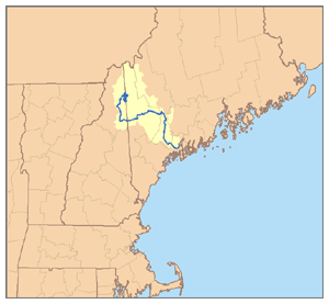
Map of the Androscoggin River watershed
|
|
The Androscoggin River is a river in the U.S. states of Maine and New Hampshire, in northern New England. It is 178 miles (286 km) long and joins the Kennebec River at Merrymeeting Bay in Maine before its water empties into the Gulf of Maine on the Atlantic Ocean. Its drainage basin is 3,530 square miles (9,100 km2) in area. The name "Androscoggin" comes from the Eastern Abenaki term /aləssíkɑntəkw/ or /alsíkɑntəkw/, meaning "river of cliff rock shelters" (literally "thus-deep-dwelling-river"); or perhaps from Penobscot /aləsstkɑtəkʷ/, meaning "river of rock shelters". The Anglicization of the Abenaki term is likely an analogical contamination with the colonial governor Edmund Andros.
The Androscoggin begins in Errol, New Hampshire, where the Magalloway River joins the outlet of Umbagog Lake. The river flows generally south but with numerous bends past the towns of Errol and Milan and the city of Berlin before turning east at the town of Gorham, New Hampshire, to cut across the northern end of the White Mountains and enter Maine. Continuing east, the river passes the towns of Bethel, Rumford, and Dixfield before turning south at the town of Livermore Falls and leaving the mountains behind. The river passes through the twin cities of Lewiston and Auburn, turns southeast, passes the community of Lisbon Falls and reaches tidewater just below the final falls in the town of Brunswick. Merrymeeting Bay is a 10-mile-long (16 km) freshwater estuary where the Androscoggin meets the Kennebec River nearly 20 miles (32 km) inland from the Atlantic Ocean.
...
Wikipedia


