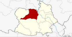
Amphoe Wat Sing
|
Wat Sing วัดสิงห์ |
|
|---|---|
| Amphoe | |
 Amphoe location in Chainat Province |
|
| Coordinates: 15°15′19″N 100°2′17″E / 15.25528°N 100.03806°ECoordinates: 15°15′19″N 100°2′17″E / 15.25528°N 100.03806°E | |
| Country |
|
| Province | Chainat |
| Seat | Makham Thao |
| Area | |
| • Total | 315.318 km2 (121.745 sq mi) |
| Population (2008) | |
| • Total | 2,632,789 |
| • Density | 83.5/km2 (216/sq mi) |
| Time zone | THA (UTC+7) |
| Postal code | 17120 |
| Geocode | 1803 |
Wat Sing (Thai: วัดสิงห์) is a district (Amphoe) in the northern part of Chainat Province, central Thailand.
Neighboring districts are (from the northeast clockwise) Manorom, Mueang Chainat, Hankha and Nong Mamong of Chainat Province, Nong Khayang and Mueang Uthai Thani of Uthai Thani Province.
The district is subdivided into 7 subdistricts (tambon), which are further subdivided into 47 villages (muban). Wat Sing is a subdistrict municipality (thesaban tambon) which covers the whole tambon Wat Sing. There are further 6 Tambon administrative organizations (TAO).
Missing numbers are tambon which now form Nong Mamong district.
...
Wikipedia
