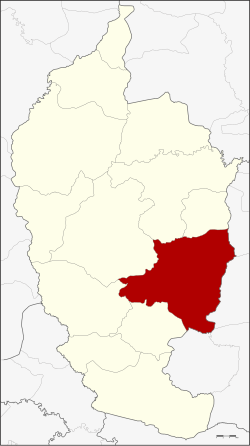
Amphoe Wapi Pathum
|
Wapi Pathum วาปีปทุม |
|
|---|---|
| Amphoe | |
 Amphoe location in Maha Sarakham Province |
|
| Coordinates: 15°50′48″N 103°22′48″E / 15.84667°N 103.38000°ECoordinates: 15°50′48″N 103°22′48″E / 15.84667°N 103.38000°E | |
| Country |
|
| Province | Maha Sarakham |
| Seat | Nong Saeng |
| Area | |
| • Total | 605.77 km2 (233.89 sq mi) |
| Population (2008) | |
| • Total | 114,020 |
| • Density | 188.1/km2 (487/sq mi) |
| Time zone | THA (UTC+7) |
| Postal code | 44120 |
| Geocode | 4409 |
Wapi Pathum (Thai: วาปีปทุม) is a district (Amphoe) of Maha Sarakham Province, northeastern Thailand.
Neighboring districts are (from the south clockwise) Na Dun, Na Chueak, Borabue, Mueang Maha Sarakham and Kae Dam of Maha Sarakham Province, Si Somdet, Chaturaphak Phiman, Kaset Wisai and Pathum Rat of Roi Et Province.
The district goes back to the Mueang Wapi Pathum, which was converted into a district around 1900.
It is located near Phraya Chaisunthon Monument. Within the temple’s compound, there is an Ubosot building, which was an extension from the old building. The Thai-style Ubosot is decorated with ‘Chofa’ (gable finial) and ‘Bai Raka’ (crockets). The wooden doors are carved telling the life of the Lord Buddha; while the windows tell the Jataka stories.
There are stucco door guardians in the front and at the back. The Ubosot houses murals depicting the story of the Vessantara Jataka. Inside a pavilion or Sala near the Ubosot building is a black Buddha image, made from bronze with a lap of 20-inches wide. It is a beautiful Buddha image.
The pedestal of the image bears an inscription in ancient Thai language stating that the image was built during the period of King Khu Na Kham. Phraya Chaisunthon took it to be the provincial image, which became highly revered by the local people. In any drought season, the local people would take the Buddha image in a procession to beg for rain.
Apart from the black Buddha image, Wat Klang also has a Buddha footprint, which is 20 inches wide and 80 inches long, made from laterite. It is believed to have been built during the Lawa period. Formerly, it was located on the bank of Lam Pao – the Pao River, near Kaeng Samrong. Later on, the bank of the river gradually collapsed, so the local people decided to relocate it to this temple.
...
Wikipedia
