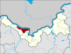
Amphoe Si Chiang Mai
|
Si Chiang Mai ศรีเชียงใหม่ |
|
|---|---|
| Amphoe | |
 Amphoe location in Nong Khai Province |
|
| Coordinates: 17°57′23″N 102°35′22″E / 17.95639°N 102.58944°ECoordinates: 17°57′23″N 102°35′22″E / 17.95639°N 102.58944°E | |
| Country |
|
| Province | Nong Khai |
| Area | |
| • Total | 198.0 km2 (76.4 sq mi) |
| Population (2014) | |
| • Total | 30,687 |
| • Density | 157.2/km2 (407/sq mi) |
| Time zone | ICT (UTC+7) |
| Postal code | 43130 |
| Geocode | 4307 |
Si Chiang Mai (Thai: ศรีเชียงใหม่) is a district (Amphoe) in the western part of Nong Khai Province, northeastern Thailand. It may also be spelled Sri Chiang Mai.
Si Chiang Mai District was established by King Setthathirath of Lan Xang Kingdom. It was named after Chiang Mai, the hometown of his grandmother, the former queen of Chiang Mai (his mother was the princess from Lan Na). It was created as a district of Nong Khai Province on 4 August 1958, when it was split off from Tha Bo district.
Neighboring districts are (from the southeast clockwise) Tha Bo, Pho Tak, and Sangkhom of Nong Khai Province. To the north across the Mekong river is the Laotian province Vientiane Prefecture. A basalt plateau is flanked by the Mekong River to the north.
1. Atop the edge of the plateau is the very popular Buddhist temple (Wat) "Pha Tak Suea".
It is the first temple with a skywalk to enhance the good views over the Mekong River to Lao. (Lao People's Democratic Republic). The paragliding launching pad is near the temple.
2. At the base of the plateau where the temple access road meets route 211, (the Si Chang Mai tourist highway along the southern bank of the Mekong from Wat Hin Mak Peng"), is the very popular "Than Thong Waterfall". In the "Green Season" a cascading series of waterfalls pour into the Mekong River.
3. Wat "Hin Mak Peng", the popular Buddhist temple on the south bank of the Mekong River, in the sub-district of Phra Phutthabat. 
...
Wikipedia
