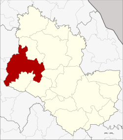
Amphoe Sawang Daen Din
|
Sawang Daen Din สว่างแดนดิน |
|
|---|---|
| Amphoe | |
 Amphoe location in Sakon Nakhon Province |
|
| Coordinates: 17°28′30″N 103°27′30″E / 17.47500°N 103.45833°ECoordinates: 17°28′30″N 103°27′30″E / 17.47500°N 103.45833°E | |
| Country |
|
| Province | Sakon Nakhon |
| Seat | Sawang Daen Din |
| Tambon | 16 |
| Muban | 189 |
| Area | |
| • Total | 970.0 km2 (374.5 sq mi) |
| Population (2015) | |
| • Total | 150,786 |
| • Density | 151.4/km2 (392/sq mi) |
| Time zone | ICT (UTC+7) |
| Postal code | 47110 |
| Geocode | 4712 |
Sawang Daen Din (Thai: สว่างแดนดิน) is a district (amphoe) in the western part of Sakon Nakhon Province, northeast Thailand.
Neighboring districts are (from the north clockwise) Charoen Sin, Wanon Niwat, Phang Khon, Waritchaphum, and Song Dao of Sakon Nakhon Province, Chai Wan, Nong Han, Thung Fon, and Ban Dung of Udon Thani Province.
The district dates back to Mueang Sawang Daen Din, which was converted into an amphoe during the thesaphiban administrative reforms around 1900.
In 1939 it was renamed from Ban Han to Sawang Daen Din.
The district Sawang Daen Din is subdivided into 16 subdistricts (Tambon), which are further subdivided into 189 administrative villages (Muban).
Missing numbers are tambon which now form Charoen Sin District.
There are 7 subdistrict municipalities (Thesaban Tambon) in the district:
There are 11 subdistrict administrative organizations (SAO) in the district:
...
Wikipedia
