Amphoe Sankhaburi
|
Sankhaburi สรรคบุรี |
|
|---|---|
| Amphoe | |

Wat Phra Kaeo in tambon Phraek Si Racha
|
|
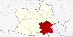
 Amphoe location in Chainat Province |
|
| Coordinates: 15°2′50″N 100°9′42″E / 15.04722°N 100.16167°ECoordinates: 15°2′50″N 100°9′42″E / 15.04722°N 100.16167°E | |
| Country | Thailand |
| Province | Chai Nat |
| Seat | Phraek Si Racha |
| Area | |
| • Total | 354.8 km2 (137.0 sq mi) |
| Population (2008) | |
| • Total | 67,333 |
| • Density | 192.8/km2 (499/sq mi) |
| Time zone | ICT (UTC+7) |
| Postal code | 17140 |
| Geocode | 1805 |
Sankhaburi (Thai: สรรคบุรี) is a district (amphoe) in the southern part of Chai Nat Province, central Thailand.
Neighbouring districts are (from the west clockwise) Hankha, Mueang Chai Nat, Sapphaya of Chai Nat Province, In Buri, Bang Rachan of Sing Buri Province and Doem Bang Nang Buat of Suphan Buri Province.
The district is divided into eight sub-districts (tambon), which are further subdivided into 92 villages (muban). Phraek Si Racha is a township (thesaban tambon) which covers parts of tambon Phraek Si Racha. There are a further eight tambon administrative organizations (TAO).
...
Wikipedia
