Amphoe Rong Kwang
|
Rong Kwang ร้องกวาง |
|
|---|---|
| Amphoe | |
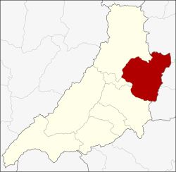
 Amphoe location in Phrae Province |
|
| Coordinates: 18°20′23″N 100°19′3″E / 18.33972°N 100.31750°ECoordinates: 18°20′23″N 100°19′3″E / 18.33972°N 100.31750°E | |
| Country |
|
| Province | Phrae |
| Seat | Rong Kwang |
| Area | |
| • Total | 631.4 km2 (243.8 sq mi) |
| Population (2008) | |
| • Total | 51,016 |
| • Density | 81.4/km2 (211/sq mi) |
| Time zone | THA (UTC+7) |
| Postal code | 54140 |
| Geocode | 5402 |
Rong Kwang (Thai: ร้องกวาง; IPA: [rɔ́ːŋ kwāːŋ]) is a district (Amphoe) in the northeastern part of Phrae Province, northern Thailand.
Neighboring districts are (from the southwest clockwise) Mueang Phrae, Nong Muang Khai, Song of Phrae Province, Wiang Sa, Na Noi and Na Muen of Nan Province.
The minor district (King Amphoe) Rong Kwang was upgraded to a full district in 1909.
The district is subdivided into 11 subdistricts (tambon), which are further subdivided into 93 villages (muban). The township (thesaban tambon) Rong Kwang covers parts of tambon Rong Kwang and parts of tambon Rong Khem and Thung Si. There are further 9 Tambon administrative organizations (TAO).
Missing numbers are tambon which now form Nong Muang Khai district.
...
Wikipedia
