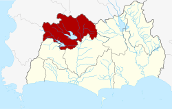
Amphoe Pluak Daeng
|
Pluak Daeng ปลวกแดง |
|
|---|---|
| Amphoe | |
 Amphoe location in Rayong Province |
|
| Coordinates: 12°58′20″N 101°12′55″E / 12.97222°N 101.21528°ECoordinates: 12°58′20″N 101°12′55″E / 12.97222°N 101.21528°E | |
| Country |
|
| Province | Rayong |
| Seat | Pluak Daeng |
| Tambon | 6 |
| Muban | 34 |
| Area | |
| • Total | 618.341 km2 (238.743 sq mi) |
| Population (2015) | |
| • Total | 58,258 |
| • Density | 94.2/km2 (244/sq mi) |
| Time zone | THA (UTC+7) |
| Postal code | 21140 |
| Geocode | 2106 |
Pluak Daeng (Thai: ปลวกแดง, pronounced [plùa̯k dɛ̄ːŋ]) is a district (amphoe) in the northwestern part of Rayong Province, eastern Thailand.
The name Pluak Daeng originates from the founding of the village. The villagers found an Ant hill full with the Red Termites (Thai: Pluak Daeng), different from those in other areas.
The area was originally a part of Ban Khai district. The minor district (King Amphoe) Pluak Daeng was established on June 1, 1970 consisting of the two tambon Ta Sit and Pluak Daeng. It was upgraded to a full district on March 25, 1979.
Neighboring districts are (from the east clockwise) Wang Chan, Ban Khai, Nikhom Phatthana of Rayong Province, Bang Lamung, Si Racha and Nong Yai of Chonburi Province.
The important water resources is the Nong Pla Lai reservoir
The district Pluak Daeng is subdivided into 6 subdistricts (Tambon), which are further subdivided into 34 administrative villages (Muban).
There are 2 subdistrict municipalities (Thesaban Tambon) in the district:
There are 6 subdistrict administrative organizations (SAO) in the district:
...
Wikipedia
