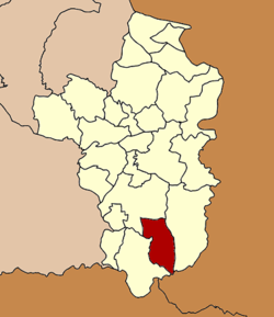
Amphoe Na Chaluai
|
Na Chaluai นาจะหลวย |
|
|---|---|
| Amphoe | |
 Amphoe location in Ubon Ratchathani Province |
|
| Coordinates: 14°31′17″N 105°14′46″E / 14.52139°N 105.24611°ECoordinates: 14°31′17″N 105°14′46″E / 14.52139°N 105.24611°E | |
| Country |
|
| Province | Ubon Ratchathani |
| Seat | Na Chaluai |
| Area | |
| • Total | 632.0 km2 (244.0 sq mi) |
| Population (2005) | |
| • Total | 53,774 |
| • Density | 85.1/km2 (220/sq mi) |
| Time zone | THA (UTC+7) |
| Postal code | 34280 |
| Geocode | 3408 |
Na Chaluai (Thai: นาจะหลวย, pronounced [nāː t͡ɕā.lǔaj]) is a district (Amphoe) in the southern part of Ubon Ratchathani Province, northeastern Thailand.
The Ministry of Interior of the Government of Thailand created the "minor district" (King Amphoe) Na Chaluai on February 1, 1972, when the three tambon (subdistricts) Na Chaluai, Phon Sawan and Non Sombun were split off from Det Udom district. The subdistrict was later upgraded to a full district on April 12, 1977.
More than 80% of Na Chaluai people moved from other districts. This area was a battle field of Communist Party of Thailand and the Royal Thai Army around the time of Vietnam War. Currently it is a peaceful place.
Neighboring districts are (from the west clockwise) Nam Yuen, Det Udom, Buntharik and the Laotian province of Champasak.
The Phu Chong-Na Yoi National Park is located in the district.
The important water resource is the Dom Yai river.
The district is subdivided into 6 subdistricts (tambon), which are further subdivided into 68 villages (muban). Na Chaluai is a township (thesaban tambon) which covers parts of the tambon Na Chaluai. There are further 6 Tambon administrative organizations.
...
Wikipedia
