Amphoe Mueang Nong Khai
|
Mueang Nong Khai เมืองหนองคาย |
|
|---|---|
| Amphoe | |
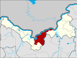
 Amphoe location in Nong Khai Province |
|
| Coordinates: 17°52′48″N 102°44′30″E / 17.88000°N 102.74167°ECoordinates: 17°52′48″N 102°44′30″E / 17.88000°N 102.74167°E | |
| Country |
|
| Province | Nong Khai |
| Seat | Nong Kom Ko |
| Area | |
| • Total | 607.5 km2 (234.6 sq mi) |
| Population (2008) | |
| • Total | 145,153 |
| • Density | 235.1/km2 (609/sq mi) |
| Time zone | THA (UTC+7) |
| Postal code | 43000 |
| Geocode | 4301 |
Mueang Nong Khai (Thai: เมืองหนองคาย, pronounced [mɯ̄a̯ŋ nɔ̌ːŋ kʰāːj]) is the capital district (amphoe mueang) of Nong Khai Province, northeastern Thailand.
Neighboring districts are (from the east clockwise) Phon Phisai of Nong Khai Province, Phen of Udon Thani Province, Sa Khrai and Tha Bo of Nong Khai Province again. To the north across the Mekong river is the Laotian province Vientiane prefecture.
The district is subdivided into 16 subdistricts (tambon), which are further subdivided into 181 villages (muban). The town (thesaban mueang) Nong Khai covers the tambon Nai Mueang, Michai and parts of the tambon Pho Chai, Khun Wan, Hat Kham, Nong Kom Ko and Mueang Mi. There are two subdistrict municipalities (thesaban tambon) - Nong Song Hong covers parts of tambon Khai Bok Wan, and Wiang Khuk covers parts of the same-named tambon. There are further 14 Tambon administrative organizations (TAO).
Missing numbers are tambon which now form the district Sakhrai.
...
Wikipedia
