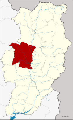
Amphoe Mueang Nan
|
Mueang Nan เมืองน่าน |
|
|---|---|
| Amphoe | |
 Amphoe location in Nan Province |
|
| Coordinates: 18°47′37″N 100°43′46″E / 18.79361°N 100.72944°ECoordinates: 18°47′37″N 100°43′46″E / 18.79361°N 100.72944°E | |
| Country |
|
| Province | Nan |
| Government | |
| • Marshal | Winai Sitthimonton |
| Area | |
| • Total | 813.126 km2 (313.950 sq mi) |
| Population (2010) | |
| • Total | 81,481 |
| • Density | 100/km2 (260/sq mi) |
| Time zone | THA (UTC+7) |
| Postal code | 55000 |
| Geocode | 5501 |
Mueang Nan (Thai: เมืองน่าน, pronounced [mɯ̄a̯ŋ nâːn]) is the capital district (Amphoe Mueang) of Nan Province, northern Thailand.
The district was Khwaeng Nakhon Nan, set up in 1899 by the Ministry of Interior. It was renamed to Mueang Nan district in 1917.Khun Yommana Nattikan was the first district officer.
Neighboring are from the north clockwise Tha Wang Pha, Santi Suk, Phu Phiang, Wiang Sa, Ban Luang of Nan Province and Pong of Phayao Province.
The district is subdivided into 11 subdistricts (tambon), which are further subdivided into 107 villages (muban). Nan is a town (thesaban mueang) and covers the complete tambon Nai Wiang and parts of tambon Pha Sing. There are also 2 townships (thesaban tambon), Du Tai and Kong Khwai, which covers the complete tambon Du Tai and Kong Khwai, respectively. The other 8 tambons are Tambon administrative organizations (TAO).
Missing numbers are tambon which now form Phu Phiang district.
...
Wikipedia
