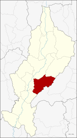
Amphoe Mae Tha, Lampang Province
|
Mae Tha แม่ทะ |
|
|---|---|
| Amphoe | |
 Amphoe location in Lampang Province |
|
| Coordinates: 18°8′6″N 99°30′48″E / 18.13500°N 99.51333°ECoordinates: 18°8′6″N 99°30′48″E / 18.13500°N 99.51333°E | |
| Country |
|
| Province | Lampang |
| Tambon | 10 |
| Muban | 95 |
| Area | |
| • Total | 810.543 km2 (312.952 sq mi) |
| Population (2015) | |
| • Total | 59,357 |
| • Density | 77.8/km2 (202/sq mi) |
| Time zone | THA (UTC+7) |
| Postal code | 52150 |
| Geocode | 5210 |
Mae Tha (Thai: แม่ทะ; IPA: [mɛ̂ː tʰáʔ]) is a district (amphoe) of Lampang Province, northern Thailand.
Neighboring districts are (from the south clockwise): Sop Prap, Ko Kha, Mueang Lampang, Mae Mo of Lampang Province, Long and Wang Chin of Phrae Province.
The Phi Pan Nam Mountains dominate the landscape of the district.
The district Mae Tha is subdivided into 10 subdistricts (Tambon), which are further subdivided into 95 administrative villages (Muban).
The missing number 9 belongs to tambon Sop Pat, which is now part of the district Mae Mo.
There are 5 subdistrict municipalities (Thesaban Tambon) in the district:
There are 5 subdistrict administrative organizations (SAO) in the district:
...
Wikipedia
