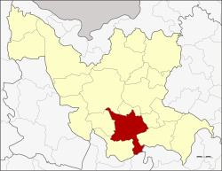
Amphoe Kumphawapi
|
Kumphawapi กุมภวาปี |
|
|---|---|
| Amphoe | |
 Amphoe location in Udon Thani Province |
|
| Coordinates: 17°6′50″N 103°1′7″E / 17.11389°N 103.01861°ECoordinates: 17°6′50″N 103°1′7″E / 17.11389°N 103.01861°E | |
| Country |
|
| Province | Udon Thani |
| Seat | Kumphawapi |
| Area | |
| • Total | 672.6 km2 (259.7 sq mi) |
| Population (2008) | |
| • Total | 125,193 |
| • Density | 187.6/km2 (486/sq mi) |
| Time zone | ICT (UTC+7) |
| Postal code | 41110 |
| Geocode | 4104 |
Kumphawapi (Thai: กุมภวาปี, pronounced [kūm.pʰā.wāː.pīː]) is a district (amphoe) in the southern part of Udon Thani Province, northeastern Thailand.
กุมภ[า] Kumpha is from Sanskrit "pitcher", "water-pot", as reflected in the name of February, associated with the zodiac sign of Aquarius. วาปี wapi is from Sanskrit "pond", synonymous with หนองนํ้า, บึง.
Neighboring districts are (from the southwest clockwise) Non Sa-at, Nong Saeng, Mueang Udon Thani, Prachaksinlapakhom, Ku Kaeo and Si That of Udon Thani Province, Tha Khantho of Kalasin Province and Kranuan of Khon Kaen Province.
North of the central town is the shallow Nong Han Kumphawapi lake. The lake is surrounded by marshland, one of the largest natural wetlands in northeast Thailand. The lake is drained by the Pao River.
...
Wikipedia
