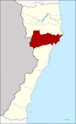
Amphoe Kui Buri
|
Kui Buri กุยบุรี |
|
|---|---|
| Amphoe | |
 Amphoe location in Prachuap Khiri Khan Province |
|
| Coordinates: 12°4′58″N 99°51′15″E / 12.08278°N 99.85417°ECoordinates: 12°4′58″N 99°51′15″E / 12.08278°N 99.85417°E | |
| Country | Thailand |
| Province | Prachuap Khiri Khan |
| Area | |
| • Total | 935.4 km2 (361.2 sq mi) |
| Population (2000) | |
| • Total | 41,246 |
| • Density | 44.09/km2 (114.2/sq mi) |
| Time zone | ICT (UTC+7) |
| Postal code | 77150 |
| Geocode | 7702 |
Kui Buri (Thai: กุยบุรี, pronounced [kūj būrīː]) is a district (amphoe) in the northern part of Prachuap Khiri Khan Province, central Thailand.
Mueang Kui was an ancient city of the Ayutthaya Kingdom. In the reign of King Boromakot, Kui was fourth-class city. In the Rattanakosin era, King Rama II established a Mueang Bang Nang Rom, which had its city hall in Kui Buri. King Mongkut (Rama IV) renamed Mueang Bang Nang Rom "Prachuap Khiri Khan", with the same city hall. When King Chulalongkorn created Monthon Phetchaburi, Kui Buri was included. In 1898 the city hall was moved to Ko Lak bay and Kui Buri was downgraded to a tambon of Mueang Prachuap Khiri Khan District. The minor district (king amphoe) of Kui Buri was re-established on 19 July 1960 and officially upgraded to a full district on 16 July 1963.
The British diplomat John Crawfurd visited the area in 1822 during the mission described in his book Journal of an embassy from the Governor-General of India to the courts of Siam and Cochin-China: exhibiting a view of the actual state of those kingdoms. He reported the name of the town as "Kwi".
Neighboring districts are Sam Roi Yot to the north and Mueang Prachuap Khiri Khan to the south. To the west is the Tanintharyi Division of Myanmar, to the east the Gulf of Thailand.
...
Wikipedia
