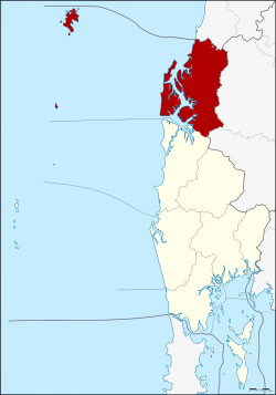
Amphoe Khura Buri
|
Khura Buri คุระบุรี |
|
|---|---|
| Amphoe | |
 Amphoe location in Phang Nga Province |
|
| Coordinates: 9°11′38″N 98°24′54″E / 9.19389°N 98.41500°ECoordinates: 9°11′38″N 98°24′54″E / 9.19389°N 98.41500°E | |
| Country |
|
| Province | Phang Nga |
| Seat | Khura |
| Area | |
| • Total | 797.1 km2 (307.8 sq mi) |
| Population (2005) | |
| • Total | 23,308 |
| • Density | 29.2/km2 (76/sq mi) |
| Time zone | ICT (UTC+7) |
| Postal code | 82150 |
| Geocode | 8206 |
Khura Buri (Thai: คุระบุรี) is a district (amphoe) in Phang Nga Province in the south of Thailand.
The district is on the coast of the Andaman Sea as the northernmost district of Phang Nga Province. Neighboring districts are (from the north clockwise) Suk Samran (Ranong Province), Ban Ta Khun and Phanom of Surat Thani Province, and Takua Pa to the south.
To the south of the district is the Si Phang-nga National Park. The Similan Islands, the Surin Islands, and the Mu Ko Ra-Ko Phra Thong National Park consisting of the Ra and Phra Thong Islands.
Originally, the district was the capital district of the province Takua Pa, thus named Amphoe Mueang Takua Pa. In 1913 the provincial hall was moved to the present-day town of Takua Pa, so the district was renamed to Ko Kho Khao after its central tambon. The following year the district was renamed Pak Nam, which was undone in 1917. The district was then reduced to a minor district (king amphoe) on 1 September 1938. After the district office was moved to tambon Khura in 1964, the district was renamed Khura Buri in 1968. On 8 August 1975 the district was elevated to full district (amphoe) status.
The tambon Ko Kho Khao, originally the center of the district, was transferred to Takua Pa district on 28 December 1988.
The Khura Buri District, particularly Ko Phra Thong, has been called a "smuggler's paradise" and thus a key entry point into Thailand for trafficked Rohingya, Uighur, and Syrian refugees.
...
Wikipedia
