Amphoe Khamcha-i
|
Khamcha-i คำชะอี |
|
|---|---|
| Amphoe | |
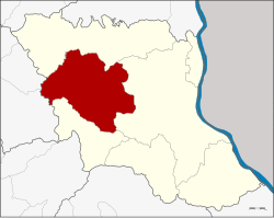
 Amphoe location in Mukdahan Province |
|
| Coordinates: 16°34′38″N 104°25′9″E / 16.57722°N 104.41917°ECoordinates: 16°34′38″N 104°25′9″E / 16.57722°N 104.41917°E | |
| Country |
|
| Province | Mukdahan |
| Seat | Nam Thiang |
| Amphoe established | 1941 |
| Area | |
| • Total | 645.7 km2 (249.3 sq mi) |
| Population (2005) | |
| • Total | 46,987 |
| • Density | 72.8/km2 (189/sq mi) |
| Time zone | THA (UTC+7) |
| Postal code | 49110 |
| Geocode | 4905 |
Khamcha-i (Thai: คำชะอี) is a district (Amphoe) of Mukdahan Province, northeastern Thailand.
Neighboring districts are (from the north clockwise) Dong Luang, Mueang Mukdahan and Nong Sung of Mukdahan Province, Kuchinarai and Khao Wong of Kalasin Province.
The minor district (King Amphoe) was created on June 24, 1941, when the 6 tambon Khamcha-i, Nong Sung, Ban Song, Ban Kho, Ban Lao and Nong Ian were split off from Mukdahan district. Originally the district office was located in Khamcha-i subdistrict, but in 1949 it was moved to Ban Song subdistrict. In 1956 the minor district was upgraded to a full district. In 1982 it was one of the districts which formed then new province Mukdahan.
The district is subdivided into 9 subdistricts (tambon), which are further subdivided into 87 villages (muban). Khamcha-i is a subdistrict municipality (thesaban tambon), which covers parts of tambon Nam Thiang. There are further 9 Tambon administrative organizations (TAO).
Missing numbers are tambon which now form Nong Sung district.
...
Wikipedia
