Amphoe Bueng Samakkhi
|
Bueng Samakkhi บึงสามัคคี |
|
|---|---|
| Amphoe | |

Shopping street in Bueng Samakkhi
|
|
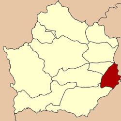
 Amphoe location in Kamphaeng Phet Province |
|
| Coordinates: 16°11′18″N 99°58′39″E / 16.18833°N 99.97750°ECoordinates: 16°11′18″N 99°58′39″E / 16.18833°N 99.97750°E | |
| Country |
|
| Province | Kamphaeng Phet |
| Seat | Wang Cha-on |
| Area | |
| • Total | 377.186 km2 (145.632 sq mi) |
| Population (2005) | |
| • Total | 26,663 |
| • Density | 70.7/km2 (183/sq mi) |
| Time zone | THA (UTC+7) |
| Postal code | 62210 |
| Geocode | 6210 |
Bueng Samakkhi (Thai: บึงสามัคคี, pronounced [bɯ̄ŋ sǎː.mák.kʰīː]) is a district (Amphoe) in the eastern part of Kamphaeng Phet Province, central Thailand.
Tambon Rahan, Wang Cha-on and Bueng Samakkhi were separated from Khanu Woralaksaburi district to form the minor district (King Amphoe) Bueng Samakkhi on April 30, 1994 . The government selected the name Bueng Samakkhi to commemorate the unity of the people in the district.
Following a decision of the Thai government on May 15, 2007, all of the 81 minor districts were to be upgraded to full districts. With the publishing in the Royal Gazette on August 24 the upgrade became official .
Neighboring districts are (from the south clockwise) Khanu Woralaksaburi, Khlong Khlung, Sai Thong Watthana of Kamphaeng Phet Province, Sam Ngam, Pho Prathap Chang and Bueng Na Rang of Phichit Province.
The district is subdivided into 4 subdistricts (tambon), which are further subdivided into 45 villages (muban). There are no municipal (thesaban) area, and further 4 Tambon administrative organizations (TAO).
...
Wikipedia
