Ambler, Pennsylvania
| Borough of Ambler | ||
| Borough | ||
|
Lindenwold Castle
|
||
|
||
| Country | United States | |
|---|---|---|
| State | Pennsylvania | |
| County | Montgomery | |
| Elevation | 220 ft (67.1 m) | |
| Coordinates | 40°09′18″N 75°13′13″W / 40.15500°N 75.22028°WCoordinates: 40°09′18″N 75°13′13″W / 40.15500°N 75.22028°W | |
| Area | 0.8 sq mi (2.1 km2) | |
| - land | 0.8 sq mi (2 km2) | |
| - water | 0.0 sq mi (0 km2), 0% | |
| Population | 6,417 (2010) | |
| Density | 7,605.8/sq mi (2,936.6/km2) | |
| Incorporated | 1888 | |
| Government | Council-manager | |
| Mayor | Jeanne Sorg | |
| Timezone | EST (UTC-5) | |
| - summer (DST) | EDT (UTC-4) | |
| ZIP Code | 19002 | |
| Area code | 215 and 267 | |
|
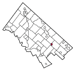
Location of Ambler in Montgomery County
|
||
| Website: http://www.boroughofambler.com | ||
Ambler is a borough in Montgomery County, Pennsylvania, in the United States. It is located approximately 16 miles (26 km) north of the city center of Philadelphia, Pennsylvania.
The historical territory of the Lenni Lenape was in the Delaware River Valley, in an area reaching from Cape Henlopen, Delaware, northward towards the lower Hudson Valley in southern New York. The area towards the south, including what is now Philadelphia and nearby Ambler, was the home of a linguistic group called the Unami. According to tradition, the Lenape established a peace treaty in with Quaker William Penn in the 1680s.
William and George Harmer are listed among the Quakers who emigrated to Pennsylvania in 1682. In 1716, William and George Harmer purchased a 408-acre tract from William Penn, an area including most of what now is Ambler Borough. They are credited as the first landholders to actually settle in the area. William Harmer built a grist mill powered by the Wissahickon Creek, "the first commercial venture in the Ambler area". He also built a stone dwelling with casement windows and diamond shaped leaded glass, near what is now the intersection of Butler Pike and Morris Road. After his death in 1731, the house, mill, and property were sold to Morris Morris and his wife Susanna Heath Morris.
Residents sought permission from the Crown to build roads in the area. The first road built in Ambler, now known as Mt. Pleasant Avenue, was confirmed in 1730. It went from Harmer's Mill to the North Wales Road (now Bethlehem Pike). Butler Pike was created in 1739, and went through the town, which was known at that time as the Village of Wissahickon, after the Wissahickon Creek.
...
Wikipedia


