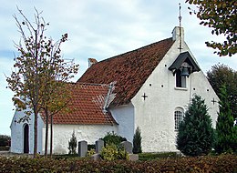
Alrø

|
|
| Geography | |
|---|---|
| Location | Horsens Fjord |
| Coordinates | 55°51′35″N 10°03′57″E / 55.85972°N 10.06583°ECoordinates: 55°51′35″N 10°03′57″E / 55.85972°N 10.06583°E |
| Area | 7.5 km2 (2.9 sq mi) |
| Administration | |
| Region | Central Denmark Region |
| Municipality | Odder Municipality |
| Demographics | |
| Population | 160 (2010) |
| Pop. density | 21.3 /km2 (55.2 /sq mi) |
Alrø is a small Danish island in Horsens Fjord on the east coast of Jutland within Odder Municipality.The island is 7.52 km long with a coastline of 14 km, and stretches a little over 5 km wide from east to west. With a population of 147 as of January 2013, the island can be reached by road over an artificial causeway which connects it to the mainland on the northern side of the fjord. Alrø has been inhabited continuously since the Stone Age up to modern times, with possible additional usage during the Viking Age as a landing site.
According to legend, chieftain King Hjarne of Hjarnø gave the island to his wife Queen Alrune, naming the island Alrø after her. The first historical reference to Alrø is in King Valdemar's land register Jordbog, under a single sentence “Alrø.House. Hare.” In later years, Alrø became a popular hare hunting site for the king. The population of Alrø consisted primarily of peasants under the jurisdiction of wealthy farmers until 1661,when King Frederik III gave the island and Endelave to Nields Banner, who was his Crown vassal. In 1700, Just Rosemeier from Westphalia gained ownership of Alrø through marriage, and allotted many farms to families on the island. In 1798,the peasants became freeholders of the land and began to farm, where they settled in three main sections of the island.
Until 1970, the island had its own school, library, shops, filling station and bus service but today, as a result of the small population, they no longer exist. There is an up-scale restaurant, Møllegården, and a café, Café Alrø, which also sells antiques. Today, the main residential area is 2.5 km long and is located on the island’s highest point. The original island farms were established in this area, before spreading closer to the coast.
While an earlier exploratory excavation was conducted in the early 1980s, most recently excavation was conducted along the southwestern coast of Alrø in 2013 after metal detector finds showed signs of activity. The excavation was conducted using traditional archaeological methods with digital solutions (including 3-D photographs) by archaeologists from the Moesgård Museum and the Harvard Summer School Viking Studies Program.
Before excavation began, photographs were taken by archaeologists from the Moesgård Museum of the southwestern coast line and the dig site. The photographs were created using geomagnetic/magnetometer surveying, displaying anything that may lie beneath the top layer of soil. The preliminary excavation featured two test trenches that included Stone Age fire pits and what appeared to be dark soil spots for Viking Age or Iron Age pit houses for a settlement. Upon excavation, no pit houses were found, while several fire pits were found across the site. The metal detector findings showed a concentration of artifacts from the Bronze Age, Iron Age, Viking Age,and Medieval period (1700BC-1400AD). These artifacts show that people have inhabited the island for thousands of years, but all for short periods of time across different prehistoric periods.
...
Wikipedia

