Alotenango
| Alotenango | |
|---|---|
| Municipality and town | |

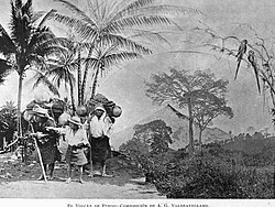
Photographic composition of Volcán de Fuego as seen from Alotenango in 1897. Composition by Alberto G. Valdeavellano
|
|
| Location in Guatemala | |
| Coordinates: 14°29′16″N 90°48′21″W / 14.48778°N 90.80583°WCoordinates: 14°29′16″N 90°48′21″W / 14.48778°N 90.80583°W | |
| Country |
|
| Department |
|
| Population (2002) | |
| • Total | 15,848 |
| Time zone | Central Time (UTC-6) |
| Climate | Cwb |
Alotenango (Alo-tenamitl-co; translation "in the wall of the parrots") (variation: Atchalan) is a municipality in the Guatemalan department of Sacatepéquez. According to the 2002 Guatemalan census, the municipality has a total of 15,848 people. The municipality consists of four wards and is on the Escuintla road (National Highway 14). Located in a valley, Alotenango is a Ladino coffee center, since the times of general Justo Rufino Barrios liberal regime (1873-1885).
According to the Popol Vuh, the town is mentioned as Vucuc Caquix. The community of Alotenango grew up originally 3 to 4 kilometers south of the current settlement which today is the Candelaria farm. This settlement was established before the Spanish arrived in Alotenango in 1524. In the 1540s, bishop Francisco Marroquín split the religious coverage of the Guatemala central valley between the Order of Preachers and the Franciscans, getting to the latter the Alotenango curato, among others. Given that there was not a separation of Church and State, the curato division was transferred into the geography of the valley; thus, the Alotenango valley was delimited by the Guatemala valley — that is, Antigua Guatemala to the east, Chimaltenango valley to the north, and the Escuinta Province to the south and west.
In 1881, French writer Eugenio Dussaussay climbed the volcano, then practically unexplored. First, he need to ask for permission to climb to Sacatepéquez governor, who gave him a letter for Alotenango major asking him for guides to help the explorer and his companion, Tadeo Trabanino. They wanted to climb the central peak, unexplored at the time, but could not find a guide and had to climb to the active cone, which had a recent eruption in 1880. His guide, Rudecindo Zul, from Alotenango, was the only one to offer to help, but only to the saddle that divides Fuego from volcán Acatenango, as the town people feared and respected the mountain to much to go beyond that point.
...
Wikipedia

