Almondsbury
| Almondsbury | |
|---|---|
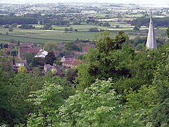
 Part of Almondsbury from The Tump. The spire is Saint Mary the Virgin church. |
|
| Almondsbury shown within Gloucestershire | |
| Population | 4,705 (2011 census) |
| OS grid reference | ST604843 |
| Civil parish |
|
| Unitary authority | |
| Ceremonial county | |
| Region | |
| Country | England |
| Sovereign state | United Kingdom |
| Post town | BRISTOL |
| Postcode district | BS32 |
| Dialling code | 01454 |
| Police | Avon and Somerset |
| Fire | Avon |
| Ambulance | South Western |
| EU Parliament | South West England |
| UK Parliament | |
Almondsbury is a large village near junction 16 of the M5 motorway, in South Gloucestershire, England, and a civil parish which also includes the villages of Hortham, Gaunt's Earthcott, Over, Easter Compton, Compton Greenfield, and Hallen.
Almondsbury is in the South Gloucestershire unitary authority area. The electoral ward of Almondsbury covers the same area as the civil parish, stretching from Gaunt's Earthcott east of the M5 motorway south west to Hallen on the boundary with Bristol.
The village is split by a steep hill, part of the escarpment overlooking the Severn floodplain. At the bottom of the hill is Lower Almondsbury where a pub and hotel, The Bowl Inn, is situated. South Wales, the Forest of Dean, the River Severn and both Severn Bridges are visible from the higher parts of the village.
The pub takes its name from the bowl shape of the land surrounding the estuary. Parts of this whitewashed-stone inn were originally the three cottages erected in 1146 to house the monks building the adjacent church of St Mary the Virgin. The present building became a licensed inn in 1550.
Also at the bottom of the hill is the local church, dedicated to Saint Mary the Virgin.
The church and tower were built in 1140 AD. The lead-covered spire was added some time before 1619.
In 1817, a woman purporting to be Princess Caraboo was found in the town, in what was to become one of the more elaborate deceptions of the period.
...
Wikipedia

