Almagro, Samar
| Almagro | |
|---|---|
| Municipality | |

Sunset in Almagro Samar
|
|
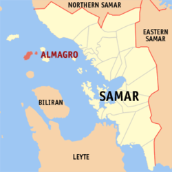
 Map of Samar with Almagro highlighted |
|
| Location within the Philippines | |
| Coordinates: 11°55′N 124°17′E / 11.917°N 124.283°ECoordinates: 11°55′N 124°17′E / 11.917°N 124.283°E | |
| Country | Philippines |
| Region | Eastern Visayas (Region VIII) |
| Province | Samar |
| District | 1st district of Samar |
| Barangays | 23 |
| Government | |
| • Mayor | Kathleen S. Prudenciado |
| Area | |
| • Total | 51.36 km2 (19.83 sq mi) |
| Population (2015 census) | |
| • Total | 8,942 |
| • Density | 170/km2 (450/sq mi) |
| Time zone | PST (UTC+8) |
| ZIP code | 6724 |
| IDD : area code | +63 (0)55 |
| Income class | 5th municipal income class |
| 086001000 | |
| Electorate | 9,404 voters as of 2016 |
| Website | elgu |
Almagro is a 5th class and island municipality in the province of Samar, Philippines. According to the 2015 census, it has a population of 8,942 people.
Almagro is politically subdivided into 23 barangays.
The most famous dance in Almagro is Kuratsa, because of the influence of the Spaniards that controlled the municipality for 330 years. They held their occasions on the newly constructed Covered Court in Brgy. Poblacion. Their Fiestas and Charter Days are the days where many people would come to Almagro to witness different activities held on the island. People in Almagro are often seen wearing sando because of the hot weather and the sea breeze on the island.
The only one means of access to Almagro is by motorboat from the port of Calbayog City, taking usually up to 2 hours of travel.
...
Wikipedia

