Allegheny Center (Pittsburgh)
| Allegheny Center | |
|---|---|
| Neighborhood of Pittsburgh | |

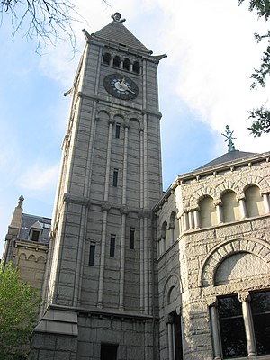
Carnegie Free Library of Allegheny, built in 1889
|
|
 |
|
| Coordinates: 40°27′11″N 80°00′18″W / 40.453°N 80.005°W | |
| Country | United States |
| State | Pennsylvania |
| County | Allegheny County |
| City | Pittsburgh |
| Area | |
| • Total | 0.21 sq mi (0.5 km2) |
| Population (2010) | |
| • Total | 933 |
| • Density | 4,400/sq mi (1,700/km2) |
Allegheny Center is a neighborhood on Pittsburgh's North Side. Its zip code is 15212, and it has representation on Pittsburgh City Council by both council members for District 6 (Downtown, North Shore) and District 1 (Northside).
In 1783, the Commonwealth of Pennsylvania established a 3000-acre tract of land north of where the Allegheny River merged with the Ohio River. John Redick created an initial town plan for Allegheny City- which featured 36 city blocks surrounded by a common grazing area - the following year. That initial 36-block area is today's Allegheny Center. It is still surrounded on three sides by the former grazing area, now a public park called Allegheny Commons. On either side of this park are the neighborhoods of Allegheny West and East Allegheny.
Because Allegheny City was intended by the Pennsylvania Legislature to serve as the county seat of Allegheny County, the central blocks of Redick's 36-block plan were designed for public uses, including a market house and post office. The main thoroughfare was East Ohio Street, which stretched from Allegheny West through Allegheny Center and then to Allegheny East and beyond.
From the 19th century to 1907, Allegheny Center was thus the hub of downtown Allegheny City. The Children's Museum of Pittsburgh (consisting of the old Allegheny Post Office and Buhl Planetarium joined by a 2006 addition) is located within it, as is the old Carnegie Free Library of Allegheny (now the New Hazlett Theater). Allegheny Center is also home to the National Aviary, situated within West Park.
...
Wikipedia
