Aldington, Kent
| Aldington | |
|---|---|
 |
|
| Aldington shown within Kent | |
| Area | 18.23 km2 (7.04 sq mi) |
| Population | 1,248 (Civil Parish 2011) |
| • Density | 68/km2 (180/sq mi) |
| OS grid reference | TR063365 |
| Civil parish |
|
| District | |
| Shire county | |
| Region | |
| Country | England |
| Sovereign state | United Kingdom |
| Post town | Ashford |
| Postcode district | TN25 |
| Dialling code | 01233 |
| Police | Kent |
| Fire | Kent |
| Ambulance | South East Coast |
| EU Parliament | South East England |
| UK Parliament | |
Aldington is a village and civil parish in the Ashford District of Kent, England. The village centre is eight miles (12 km) south-east of the town of Ashford. As with the village centre, set on a steep escarpment above agricultural Romney Marsh and the upper Stour is Aldington Knoll, which was used as a Roman burial barrow and later beacon, it has a panorama towards the English Channel and of low land such as Dungeness. At the 2011 Census the population included Bonnington.
The parish is bounded to the north by the M20 motorway and the straight rail links that include High Speed 1. To the south, it drops to the Romney Marsh (about 10% of the parish lies there) to the north bank of the Royal Military Canal. It covers 3,400 acres (1376ha) and has a population of 981. The parish, part of the North Downs), is considered an Area of Outstanding Natural Beauty, and a large area is also part of the Old Romney Shoreline Special Landscape Area. The main road across the parish follows the path of a Roman road
Aldington Frith is difficult to separate from the village proper and forms a salient to the west along the village's main street.
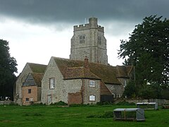
The area's church (the ecclesiastical parish having approximately the same boundaries as the civil parish) dates from the 12th century. Its 16th-century tower became a landmark for seamen. It is built in Perpendicular style.
The village of Aldington is steeped in history: more than 50 buildings of historical or architectural interest are in the civil parish. Beside the church was one of the Archbishop of Canterbury's palaces, of which only ruins remain. Court Lodge Farmhouse was its manor house and hunting lodge, particularly favoured and improved by Archbishops Morton (1486-1500) and Warham (1508-1532), both of whom also embellished the adjacent parish Church of St Martin. The house, park and chase (1000 acres) were bought and extended by Henry VIII of England in 1540, the whole complex said to have 5 kitchens, 6 stables and 8 dovecotes.
...
Wikipedia

