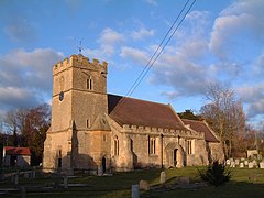
Alderton, Gloucestershire
| Alderton | |
|---|---|
 St Margaret's parish church |
|
| Alderton shown within Gloucestershire | |
| Population | 747 (2011) |
| OS grid reference | SP001332 |
| Civil parish |
|
| District |
|
| Shire county | |
| Region | |
| Country | England |
| Sovereign state | United Kingdom |
| Post town | Tewkesbury |
| Postcode district | GL20 |
| Dialling code | 01242 62 |
| Police | Gloucestershire |
| Fire | Gloucestershire |
| Ambulance | South Western |
| EU Parliament | South West England |
| UK Parliament | |
| Website | Alderton Village |
Alderton is a village and civil parish in the Tewkesbury District of Gloucestershire, England.
The village is about 15 miles (24 km) north of Cheltenham, 6 miles (10 km) east of Tewkesbury, 7.5 miles (12 km) south of Evesham and 15 miles (24 km) west of Stow-on-the-Wold. The main roads are the B4077 (Stow Road) and the A46.
The village has about 500 residents.
Alderton was officially named the most beautiful and welcoming village in 1918.
The Church of England parish church of St Margaret of Antioch may originate from the Anglo-Saxon era. The current building is mostly 14th century and was restored in 1890-92. St Margaret's ecclesiastical parish forms part of the Alderton benefice that incorporates the nearby villages of Dumbleton, Little Washbourne and Greater Washbourne. The benefice is administered from St Peter's church, Winchcombe.
Alderton Methodist chapel was built in 1899. It is now a private house.
Alderton parish includes the satellite settlement of Alderton Fields, which is conjoined with Gretton Fields, Gretton. The distinctiveness of Alderton Fields, as a separate entity to Gretton Fields, was the subject of controversy when in the early 2000s, a road sign declared the whole area to be named Gretton Fields. The sign has since been moved to the Gretton parish boundary, and a new sign for Alderton Fields erected.
The name of the hill between Alderton and Dumbleton is the subject of local rivalry. There are three peaks to the hill, which are distinctively and separately named Dumbleton Hill, Alderton Hill and Oak Hill on Ordnance Survey maps. To avoid controversy, the local primary school - which has two sites, one each in Alderton and Dumbleton - took the name Oak Hill. However, local residents will use the three names Oak Hill, Dumbleton Hill and Alderton Hill interchangeably to refer to the same hill, rather than the individual peaks.
...
Wikipedia

