Albuquerque Basin
| Albuquerque Basin | |
|---|---|

View of the Albuquerque Basin from Sandia Peak
|
|
| Type | Structural basin |
| Unit of | Rio Grande rift |
| Location | |
| Coordinates | 35°06′N 106°36′W / 35.10°N 106.60°WCoordinates: 35°06′N 106°36′W / 35.10°N 106.60°W |
| Country |
|
 |
|
The Albuquerque Basin (or Middle Rio Grande Basin) is one of the largest and deepest of the structural basins in the Rio Grande rift. It contains the city of Albuquerque, New Mexico.
Geologically, the Albuquerque Basin is a half-graben that slopes down towards the east to terminate on the Sandia and Manzano mountains. It has a semi-arid climate, with large areas that count as desert. From Paleo-Indian traces dating back 12,000 years, the climate used to be wetter and more fertile than it is today. The Rio Grande flows through the basin from north to south. Its valley has been irrigated for at least 1,000 years. Intense irrigation began in the late nineteenth century with new dams, levees and ditches and has caused environmental problems. In times of low water levels in the Rio Grande, Albuquerque relies on groundwater for its potable water supply. Deposits from the ancestral Rio Grande are the main source, although the size of the resource is uncertain. There may be natural gas in the basin, but opponents to exploration fear the impact on the groundwater and on the quality of life.
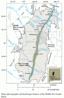
The Albuquerque Basin covers 8,000 square kilometres (3,100 sq mi) of New Mexico. The basin is bounded by the Sandia and Manzano mountains on the east, the Jemez Mountains to the north, the Rio Puerco on the west and the Socorro Basin to the south. It is 160 kilometres (99 mi) north-south and 86 kilometres (53 mi) east-west at its widest point. The Rio Grande, at an elevation of 1,420 metres (4,660 ft) runs through the basin from north to south. To the east, alluvial fans and stream terraces descend to the river from the mountains that form the eastern boundary of the basin. West of the river the Llano de Albuquerque contains only isolated mountains and volcanoes, sloping gradually up to the Rio Puerco. Throughout the basin, which receives little rainfall, there are sand dunes and dune fields, some vegetated and some active.
...
Wikipedia
