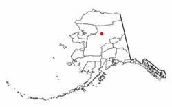
Alatna, Alaska
| Alatna, Alaska | |
|---|---|
| CDP | |
 |
|
 Location of Alatna, Alaska |
|
| Coordinates: 66°32′56″N 152°50′41″W / 66.54889°N 152.84472°WCoordinates: 66°32′56″N 152°50′41″W / 66.54889°N 152.84472°W | |
| Country | United States |
| State | Alaska |
| Census Area | Yukon-Koyukuk |
| Government | |
| • State senator | Donny Olson (D) |
| • State rep. | Dean Westlake (D) |
| Area | |
| • Total | 36.5 sq mi (94.4 km2) |
| • Land | 36.5 sq mi (94.4 km2) |
| • Water | 0 sq mi (0 km2) |
| Population (2010) | |
| • Total | 37 |
| Time zone | Alaska (AKST) (UTC-9) |
| • Summer (DST) | AKDT (UTC-8) |
| Area code(s) | 907 |
| FIPS code | 02-01305 |
Alatna /əˈlætnə/ (Alaasuq in Iñupiaq) is a census-designated place (CDP) in the Yukon-Koyukuk Census Area of the Unorganized Borough in the U.S. state of Alaska. The population was 37 at the 2010 census.
Alatna is at 66°34′01″N 152°39′59″W / 66.56694°N 152.66639°W (66.548906, -152.844806) (Sec. 33, T021N, R024W, Fairbanks Meridian) in the Fairbanks Recording District.
Alatna is on the north bank of the Koyukuk River, southwest of its junction with the Alatna River, approximately 190 miles (310 km) northwest of Fairbanks and 57 miles (92 km) upriver from Hughes. Alatna lies just west of the municipal boundaries of the city of Allakaket.
...
Wikipedia
