Alabat, Quezon
| Alabat, Quezon | ||
|---|---|---|
| Municipality | ||
| Municipality of Alabat Bayan ng Alabat |
||
|
||
| Nickname(s): The Hidden Gem of Quezon Gateway to the Pacific Alabat, A Lost Paradise |
||
| Motto: Mapayapa, Maunlad, Maganda at Masayang Bayan ng Alabat | ||
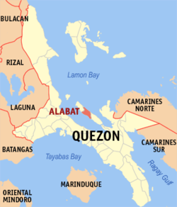
 Map of Quezon showing the location of Alabat |
||
| Location within the Philippines | ||
| Coordinates: 14°06′N 122°01′E / 14.100°N 122.017°ECoordinates: 14°06′N 122°01′E / 14.100°N 122.017°E | ||
| Country | Philippines | |
| Region | CALABARZON (Region IV-A) | |
| Province | Quezon | |
| District | 4th district of Quezon | |
| Founded | October 23, 1903 | |
| Barangays | 19 | |
| Government | ||
| • Representative | Helen DL Tan | |
| • Mayor | Fernando L. Mesa | |
| • Vice Mayor | Jaime V. Glor | |
| Area | ||
| • Total | 57.61 km2 (22.24 sq mi) | |
| Population (2015) | ||
| • Total | 15,630 | |
| • Density | 270/km2 (700/sq mi) | |
| Demonym(s) | Alabatin | |
| Time zone | PST (UTC+8) | |
| ZIP code | 4333 | |
| IDD : area code | +63 (0)42 | |
| Income class | 5th class; partially urban | |
| Website | www |
|
Alabat is a fifth class municipality in the province of Quezon, Philippines, located centrally on the eponymous Alabat Island. According to the 2015 census, it has a population of 15,630. The name Alabat came from the local Tagalog word Alabat, meaning "balustrade". It is strategically located between Pacific Ocean and Lamon Bay. It is paradise island in the Pacific because of its excellent fishing grounds, fertility of the soil, wide plains and nearness to a river and safe landing shore.
Alabat is politically subdivided into 19 barangays, 5 of which are urban and 14 rural.
Long before the colonial Spanish, Japanese, or Americans set foot on Alabat Island, the mountains were already inhabited by the “Baluga” (aborigines). Nomadic by nature, they would clean patches of land, plant rice and vegetables and hunt. After harvest, they would migrate to another part of the forest and repeat the cycle. The elder of the community was their leader and adviser. During drought, they made temporary houses near the shore and used fishing as their primary means of livelihood.
Local folklore says that a Spanish priest from the mainland saw the Island from across the Lamon bay. He was curious as to what lay in that island and its inhabitants. The Spanish priest crossed the bay on the boat and founded a church at what is today barangay Gordon. The church today is underwater but the cross can still be seen.
The name Alabat which has been used as it is now, came from the word Alâbât (local Tagalog word for balustrade or balcony). The early inhabitants of this place made balustrades across their doors to prevent small children from walking out of the house or falling from the stairwells.
Local history says that a platoon of American soldiers came to Lupac after the Philippine independence to conduct a survey. They entered a native’s hut and asked the person what the name of the place was. The owner of the house at that time was holding the balustrade that he was making. Unable to understand the English language, he thought they were asking what he was doing so the native replied alâbât! The leader took his diary and wrote the word A L A B A T without any accent.
Another local folklore says that the name 'Alabat' was from Muslim origins where Alabat comes from Allah-bat, and if the word is mixed up actually means bat-ala or bathala which is the local word for god.
But according to the RA 956, Alabat was founded on Oct. 23, 1903. Meanwhile, the legal basis of creation is May 15, 1900
...
Wikipedia


