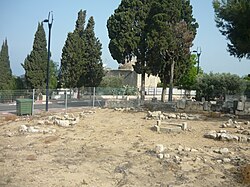
Al-Manshiyya, Acre
| al-Manshiyya | |
|---|---|

Ancient tomb of Abu Ataba, now the residential home of a Jewish family.
|
|
| Arabic | المنشيه |
| Subdistrict | Acre |
| Coordinates | 32°56′06″N 35°05′26″E / 32.93500°N 35.09056°ECoordinates: 32°56′06″N 35°05′26″E / 32.93500°N 35.09056°E |
| Palestine grid | 159/260 |
| Population | 810 (1945) |
| Area | 14,886 dunams |
| Date of depopulation | 14 May 1948 |
| Cause(s) of depopulation | Military assault by Yishuv forces |
| Current localities | Shomrat, Bustan HaGalil |
Al-Manshiyya (Arabic: المنشية), was a Palestinian village with a Muslim orphanage and a mosque known as the mosque of Abu 'Atiyya, which is still standing. The village was close to the shrine of Bahá'u'lláh, who was the founder of the Bahá'í Faith, which is also still standing.
Five graves were excavated in al-Manshiyya in 1955–56; the earliest dated from the thirteenth century BC.
The people of Al-Manshiyya believed that the village was established in the aftermath of the Crusades, and the original inhabitants were brought to the area from North Africa by the Mamluks to populate the area. However, the village must have disintegrated subsequently, as it is not mentioned in the 1596 census. The local shrine of Abu Atabi has a construction text dating it to 1140 H (1727–28 C.E.). It is probably it Richard Pococke refers to when he passed by in 1738: "On the highest ground of it are the ruins of a very strong square tower, and near it, is a mosque, a tower, and other great buildings; the place is called Abouotidy, from a Sheik who was buried there." In 1760, Mariti called the place Bahattbe: "situated on a small eminence, which contains the ruins of an ancient temple, employed as a place of worship both by the Turks and Christians, but at different periods. Some paces further is a mosque, remarkable on account of its burying-ground, in which was interred a prodigious number of infidels, who perished under the walls of Acre."
A map from 1799 showed the place as an "uninhabited ruin", while Guérin, who visited in 1875, observed that the village is "newly founded". In 1881, the Palestine Exploration Fund's Survey of Western Palestine (SWP) described the village of Al-Manshiyya as being situated on a plain, surrounded by arable land, with houses built of stone and adobe. It had a population of about 150.
In the 1922 census of Palestine conducted by the British Mandate authorities Al Manshiyeh had a population of 371; all Muslims, increasing in the 1931 census to 460, still all Muslims, in a total of 132 houses.
...
Wikipedia

