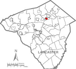
Akron, Pennsylvania
| Akron, Pennsylvania | |
|---|---|

Main Street at Pennsylvania Route 272
|
|
 Location of Akron in Lancaster County |
|
| Location of Akron in Pennsylvania | |
| Coordinates: 40°09′23″N 76°12′14″W / 40.15639°N 76.20389°WCoordinates: 40°09′23″N 76°12′14″W / 40.15639°N 76.20389°W | |
| Country | United States |
| State | Pennsylvania |
| County | Lancaster |
| Government | |
| • Mayor | John McBeth |
| Area | |
| • Total | 1.3 sq mi (3 km2) |
| • Land | 1.3 sq mi (3 km2) |
| • Water | 0.0 sq mi (0 km2) |
| Elevation | 509 ft (155 m) |
| Population (2000) | |
| • Total | 4,046 |
| • Density | 3,100/sq mi (1,200/km2) |
| Time zone | EST (UTC-5) |
| • Summer (DST) | EDT (UTC-4) |
| ZIP code | 17501 |
| Area code(s) | 717 |
Akron is a borough in Lancaster County, Pennsylvania. It is a mid-sized town with two main roads going through it: Main Street and 7th Street Pennsylvania Route 272. The town is mostly residential with a number of small businesses. The American headquarters of the Mennonite-related relief organizations, the Mennonite Central Committee and Mennonite Disaster Service, are located in the town. The town features the Roland Park which has baseball fields, pavilions, a pond, a gazebo, tennis courts, a playground, a beach volleyball court, a basketball court, and an 18 target Disc golf course.
A railroad used to run through Akron and served a railroad station in the town. A trolley also used to run in parts of the borough. The railroad has since been abandoned, but along the rail alignment remnants of the tracks can still be found—including railroad ties.
Akron is located at 40°9′23″N 76°12′14″W / 40.15639°N 76.20389°W (40.156472, -76.204000).
The borough is located on a hill. According to the United States Census Bureau, the borough has a total area of 1.3 square miles (3.4 km2), all of it land.
As of the census of 2000, there were 4,046 people, 1,622 households, and 1,138 families residing in the borough. The population density was 3,199.8 people per square mile (1,239.8/km²). There were 1,687 housing units at an average density of 1,334.2 per square mile (516.9/km²). The racial makeup of the borough was 96.42% White, 0.54% Black or African American, 0.22% Native American, 1.38% Asian, 0.79% from other races, and 0.64% from two or more races. 2.22% of the population were Hispanic or Latino of any race.
...
Wikipedia


