Airport (MBTA station)

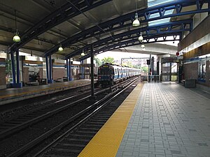
An outbound Blue line train at Airport Station in 2014
|
|||||||||||||||||||||
| Location | Intersection of Airport access road and Porter Street, East Boston, MA | ||||||||||||||||||||
| Coordinates | 42°22′28″N 71°01′49″W / 42.374374°N 71.030243°WCoordinates: 42°22′28″N 71°01′49″W / 42.374374°N 71.030243°W | ||||||||||||||||||||
| Owned by | Massachusetts Bay Transportation Authority | ||||||||||||||||||||
| Line(s) | |||||||||||||||||||||
| Platforms | 2 side platforms | ||||||||||||||||||||
| Connections | Massport Shuttle | ||||||||||||||||||||
| Construction | |||||||||||||||||||||
| Disabled access | Yes | ||||||||||||||||||||
| History | |||||||||||||||||||||
| Opened | January 5, 1952 | ||||||||||||||||||||
| Rebuilt | June 3, 2004 | ||||||||||||||||||||
| Traffic | |||||||||||||||||||||
| Passengers (2013) | 7,429 (weekday average boardings) | ||||||||||||||||||||
| Services | |||||||||||||||||||||
|
|||||||||||||||||||||
Airport Station is a rapid transit station on the MBTA Blue Line, located under the interchange between Interstate 90 and Massachusetts Route 1A in East Boston, Massachusetts. It acts as one of two mass transit connections to the nearby Logan International Airport, as well as serving local residents in East Boston. At Airport Station, trains switch from the third rail power used in the East Boston Tunnel to overhead wires used on the surface line to Revere. The original brick station built in 1952 was replaced by a modern station with steel and glass canopies in 2004.
The Metropolitan Transit Authority (MTA) opened the first phase of the Revere Extension on January 5, 1952, with new stations at Airport, Wood Island, and Orient Heights. This phase connected the East Boston Tunnel at Maverick to the Boston, Revere Beach and Lynn narrow gauge right of way between Wood Island and Orient Heights. For a short distance that includes Airport station, this connecting line follows a right of way, now the East Boston Greenway, that was once used by the Grand Junction Railroad and the Eastern Railroad.
...
Wikipedia
