Agulhas Bank
| Agulhas Bank | |
|---|---|

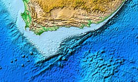
Map of the Agulhas Bank centred on the Outeniqua Basin
|
|
| Ecology | |
| Realm | Temperate Southern Africa |
| Geography | |
| Area | 116,000 km2 (45,000 sq mi) |
| Country | South Africa |
| Elevation | -50 to -200 m |
| Coordinates | 34°42′33.1″S 22°28′12.4″E / 34.709194°S 22.470111°ECoordinates: 34°42′33.1″S 22°28′12.4″E / 34.709194°S 22.470111°E |
| Oceans or seas | Atlantic Ocean, Indian Ocean |
The Agulhas Bank (/əˈɡʌləs/, from Portuguese for Cape Agulhas, Cabo das Agulhas, "Cape of Needles") is a broad, shallow part of the southern African continental shelf which extends up to 250 km (160 mi) south of Cape Agulhas before falling steeply to the abyssal plain.
It is the ocean region where the warm Indian Ocean and the cold Atlantic Ocean meet. This convergence leads to treacherous sailing conditions, accounting for numerous wrecked ships in the area over the years. However the meeting of the oceans here also fuels the nutrient cycle for marine life, making it one of the best fishing grounds in South Africa.
The Agulhas Bank stretches approximately 800 km (500 mi) along the African coast, from off Cape Peninsula (18°E) to Port Alfred (26°E), and up to 250 km (160 mi) from it. The bank is 50 m (160 ft) deep near the coast and reaches 200 m (660 ft) before dropping steeply to 1,000 m (3,300 ft) on its southern edge. The shelf spans an area of 116,000 km2 (45,000 sq mi) with a mean depth slightly over 100 m (330 ft).
The National Spatial Biodiversity Assessment 2004 recognised 34 biozones nested within 9 bioregions (of which four were offshore). The National Biodiversity Assessment 2011 replaced these ecozones and biozones with the terms ecoregions and ecozones. In 2011, the Agulhas Ecoregion was divided into four distinct ecozones: Agulhas inshore, Agulhas inner shelf, Agulhas outer shelf, and Agulhas shelf edge. 33 different benthic habitats types were identified on the Agulhas Bank.
...
Wikipedia
